Sunday, July 20th
Back when M was a child of twenty, he used to prepare for his backpacking adventures by baking cookies. They were hefty cookies–chocolate chip with butter, extra flour, lots of oats, and a little bit of wheat germ. He figured that if he took enough of these with him, along with some jerky and a few teabags, he would have a sufficiency of food. Nowadays when he goes camping with E, his diet includes others things–strange alien foods like carrots and lettuce and celery and oranges, plus the occasional masoor dahl chicken. However, there is still something to be said for cookies.

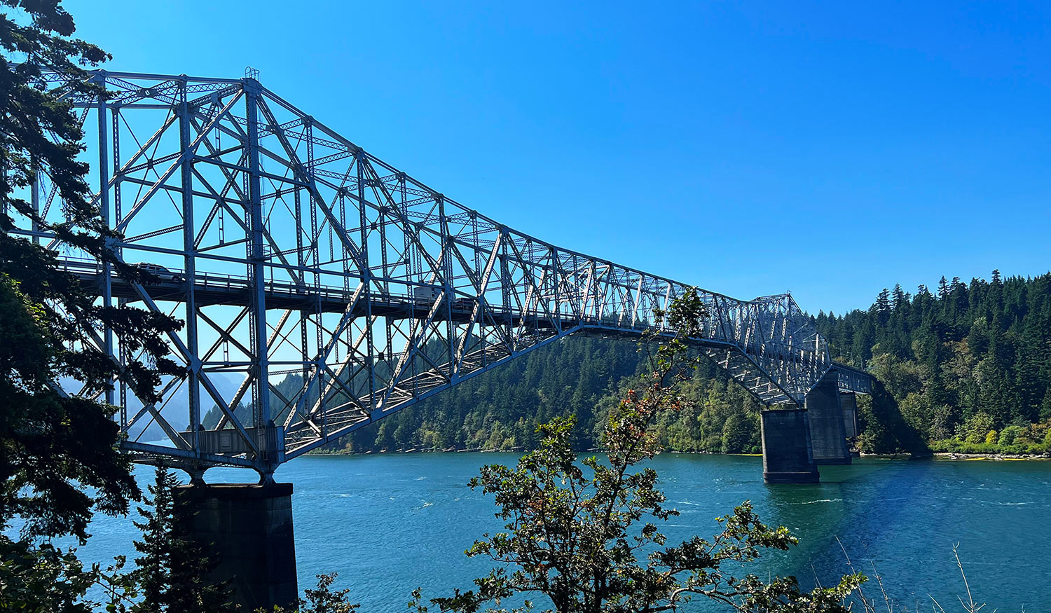
Having packed up our cookies and things, we left Corvallis at ten this morning. We drove north to Portland and then east up the Columbia River gorge. Thirty minutes from Troutdale we crossed the so-called Bridge of the Gods over to the Washington side. We gassed up in Stevenson, Washington. (Yes, we took a gas powered vehicle. Not many chargers available in the forest.)
At Carson, Washington we turned north, away from the river and up into the forests of the Washington Cascades. At around 2:00 in the afternoon, we stopped at a campground called Paradise Creek, where we were hoping to find an open spot. We knew that all the reservable spots would have long been taken. But we also knew that the campground had twelve first come first serve places (FCFS’s). We had planned our trip to get us there early enough in the day to maybe snag one. And it turned out that there were three open spots; we picked one and felt very much relieved.
The Paradise Creek campground turned out to be amazing. The campsites are all situated within a large stand of old growth trees: huge firs and cedars with trunks more than six feet across and crowns so high that it hurts your neck to see them.


When dinner time came, we realized that we had forgotten to bring certain key elements of our planned meal. So we had lettuce and mayonnaise sandwich made on pan fried hamburger buns. To accompany this, we chose to share a canned Cuervo margarita, nicely chilled. When it was time for dessert, we found that we had brought along quite a number of cookies. Later, E had her first experience sleeping in the back of the truck. It was very comfortable, she reports, but also claustrophobic.
Monday, July 21st
Our goal for Day 2 was to reach a place called Windy Ridge, where there were supposed to be some fine views of the Mt. St. Helens area. This wasn’t going to be easy, however, because we had found out just before we left Corvallis that the road we planned to take had been closed by a landslide. We had sketched out a detour, but it was long and complicated. You can see it on the right hand map below. The left hand map shows the route we had originally planned.


We started out at 8:30, making good time on a wide two lane road. Soon we came to a sign that told us to turn left to go to Windy Ridge. Sadly, another sign just beside it indicated that the route was actually closed, as we had suspected. At that point, the great detour adventure began. M drove while E kept track of our progress in our Benchmark Washington Road and Recreation Atlas. The views along the way started out nice and soon got even nicer. The roads, of course, got worse, becoming narrower and narrower and also turning to gravel. Fortunately, some of the critical road junctions had signage that helped us choose our turns. Also our atlas was excellent, so we never got lost. But there was no way to make the drive any shorter or the roads any smoother.
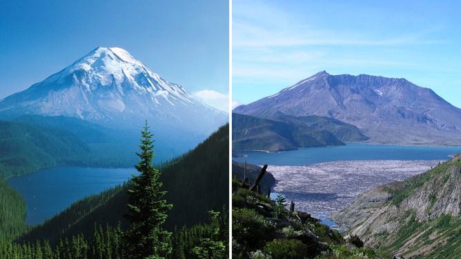
Finally, after about four hours, we got to a place where we knew we were heading straight for Windy Ridge and that we were probably not much more than an hour away. That was when we ran into road construction. Yup, road construction high in the mountains and deep in the forest. We stopped behind three other vehicles and noticed that the occupants were mostly out of their cars, either walking around or sitting in the middle of the road chewing the fat. We asked one fellow what was going on and found out we could expect a delay of at least twenty minutes. Great. On the other hand, it was 12:30; so we broke out our peanut butter and jelly sandwiches, Kettle chips, and little cans of juice and had a picnic on the shoulder of the road. After lunch we started the last leg of our journey. A half hour later we got our first glimpse of Mount St. Helens. Though the mountain was still many miles away, the slopes around us showed signs of the destruction that occurred forty-five years ago. The area is thick with trees, but the living trees are uniformly young. Only a few gray-white ghost trees remain from the 1980 forest. The ghosts are trees that were killed by the blast but not blown down.

Back in May of 1980, in the weeks before the eruption, it became clear that something big was about to happen. Authorities first ordered the evacuation of an area within four miles of the mountain. That was called the red zone and contained a popular recreation area that held lodges, campgrounds, and youth camps. In addition to the red zone, officials also established a blue zone. This was a larger circle that extended fifty miles in every direction from the mountain. Evacuation was ordered for the blue zone also, but this was considered by some to be a ridiculous excess of caution. As a kind of compromise, evacuees were allowed to re-enter the blue zone temporarily if they could show good cause. When the mountain erupted, the lodges and camps in the red zone were all empty and only two people died. Within the blue zone, fifty-four people were killed.


We took this photo as we were leaving. The clouds had lifted quite a bit and we could almost see the top. It’s still a big mountain, but it’s not what it was.
By the time we had viewed all we wanted to view it was 3:00 in the afternoon and we were tired. We had no time to rest though, as we had at least two more hours of driving before we reached our next planned stop: a motel in the town of Morton. Morton wasn’t all that far away, but for much of the route a person didn’t want to go more than 30 mph. Only on the last stretch could E put the pedal to the metal. We rolled into town at 5:00.
Tuesday, July 22nd
In the morning we drove Hwy 12 west to I-5 and took the sensible route home, making just one stop. At Bridgeport Village we had coffee and a sandwich at Peet’s and also dropped into REI. That was necessary because E had some patronage credit that she was itching to spend. She got some new sunglasses and a lightweight summer blouse. Also a new pair of hiking shorts for M. It was, after all, his birthday.
Wednesday, July 23rd
E had lunch with her THEPAJ group at Tarntip. When the family that owns Tarntip first came to town– lo, those many years ago–two sisters came to study with us at the English Language Institute. Today K took the time to come out from the kitchen and chat with the group. Very nice.
Friday, July 25th
Wonderful weather today, not too hot. This was good since we’d planned to go hiking. After getting back from that excursion, we had a quick dinner and then went to hear some live music. It was Celtic Festival weekend in Corvallis and the headline musical performance was by a group called Open the Door for Three. The three were a fiddler, an uilleann piper, and a bouzouki player/vocalist. They were very good. The concert was at PRAX, where we had never been, so that was also part of the fun.
Saturday, July 26th
In the morning we visited the Saturday Market to see another Celtic Festival event: a free performance by a marching bagpipe band. While we were there, we bought some blackberries. Later in the day, we drove the Road Shark up to Salem, where the Andees met us for dinner at the India Palace. M got another b-day present, a jigsaw version of a portrait of Gertrudis Gomez de Avellaneda by Federico Madrazo. It was a lovely second birthday dinner. M also also enjoyed the drive to and from Salem. He is still learning about the little Beamer, so on the way home, when it started to get dark, he had to pull over and spend some time figuring out how to turn the lights on.
Sunday, July 27th
Two words: blackberry pie.
Feliz Cumpleanos a tu!! 🎂🎉🎶
My uncle speaks more Spanish than I’d thought!
Also, I’m still slack-jawed at the whole story of Mt St Helens.
Great sojourn …. You two are fun travelers. I enjoyed another blog. Happy Belated Birthday Michael!🎂🎉🍷