We went down to Eugene today. E wanted to visit the Lululemon store there. Strangely enough, the shop is just across the street from the Euphoria Chocolate shop, which is just two doors away from a very nice Thai restaurant. What a serendipitous non-coincidence! On our way back to Corvallis, we stopped at Peoria Gardens, a big wholesale nursery. E had just found out that for two weeks a year Peoria Gardens opens to the public and that this was one of those weeks. We wanted to check it out.
Hot weather seems to have settled in pretty good around here, so maybe this is not the best time to be adding new plants. But the prices! We ended up getting three plants for just $21. Now, do we have the strength to get them into the ground?
Saturday, July 12th
Well… E struck first, getting her new sunflower planted early this morning. Two more to go.
Later in the morning, we went to an event put on by the Letitia Carson Legacy Project out on Tampico Road, just north of Corvallis. The LCLP is jointly sponsored by Oregon Black Pioneers, Oregon State University, Black Oregon Land Trust, and Linn-Benton NAACP. Carson was a farmer and homesteader who first came to the Corvallis area in 1849 and hers is quite a story. She was born into slavery in Kentucky around 1816. By September of 1844 she was living in Missouri with a man named David Carson, a naturalized Irish immigrant and the father of her unborn child. In the Spring of 1845 the two joined a large group of immigrants on a journey from Missouri to Oregon. Their daughter Martha was born in June of 1945 as they were crossing Nebraska. In late 1845 they reached Oregon and David filed a homestead claim for 640 acres in Benton County just north of Corvallis. They built a house on the land in the spring of 1846.
The Carson land claim is now a part of Oregon State University and is managed by the Department of Animal and Rangeland Science. One way in which the University supports the LCLP is by giving permission to hold outreach events in an area that is normally closed to the public. When we arrived, the pasture gate was open and cars were parked on the grass. We met our hosts and the other tour members under a canopy, signed our waivers, and set off for a two-mile walk. Our guide led us out of the pasture and into a riparian area of large trees and thick understory on the banks of Soap Creek. The project had recently created a path through this area leading to the site of the Carson residence. The path begins at a place where some young trees have formed a kind of archway.
Our guide, seen here in the center, called this the Fairy Portal. We liked her right away.
On its way to the homesite, the trail passes a number of large fruit trees which have been long untended. The oldest of these is this huge pear three that is estimated to be around 200 years old. It is possible that the Carsons walked past this tree when it was a youngster.
There were a number of other large apple and cherry trees in the area, all growing wild. They are not nearly as old as the pear, but they are almost certainly descended from trees planted by early settlers. At the same time, the area hosts an array of native plants including large oak, maple and ash trees, as well as many types of understory plants, some of which are also growing in our back yard. Unlike our yard, however, this small area is real wild land, settled 175 years ago but neglected for the last hundred or so.
Nothing remains of the Carson House; but the trail does take you to the spot where the house probably stood, right where E is walking in the photo below. Just behind the main mass of foliage in the picture, there is a year round stream, which would have been their water source.
None of the current trees are old enough to have been present back when the house was here, but they are likely the descendants of trees that were there.
The meadowland portion of the Carson claim was located immediately to the east of the homesite, so they would have been able to keep an eye on their stock. Nowadays–one hundred and seventy-five years later–there are still cows pastured where theirs were, as the area is part of the range of OSU’s Cattle Research Herd.
The Carson homestead seems to have thrived for a time and in September of 1849, they had another child, this time a son. In 1852, however, David Carson fell ill and died. Letitia’s status at this point was unclear. As Zachary Stocks puts in his Oregon Encyclopedia article, “While Letitia was likely Carson’s slave at some point, she would later claim to have been his free domestic servant and identified as his widow after his death.”
Upon David’s death, Benton County authorities determined that Letitia had no right of inheritance or any other claim to the property, which left her and her two children homeless. The land and goods were auctioned off and the proceeds were distributed to David Carson’s relatives in North Carolina. But that was far from the end of the story. First, we know that Letitia attended the auction and paid $104.87 to buy back what she could of her own possessions: a washtub, a pot, a skillet and lid, six plates, a bed and bedding, two cows, and a calf. Next, she joined another group of settlers headed for another land claim area, this time in Douglas County, 160 miles to the south.
In 1854, while living in Douglas County, she engaged a Corvallis lawyer and filed a lawsuit seeking damages for her losses in Benton County. The suit went to trial and ended with a hung jury. The case was then retried. In the second trial twelve white male jurors unanimously found in her favor and awarded her damages. There was then a third trial concerning the separate matter of who owned the Carson’s herd of 34 cattle. During this trial a neighbor testified that David Carson himself, in the year before his death, had stated that “only seven of cattle were his and the rest belonged to Letitia.” All told, Letitia Carson was awarded $1500 plus $230 in court costs.
In 1863 Carson filed her own homestead claim on a 160 acre tract near her new home in Douglas County. In 1869, after making the required improvements, she applied for and received certification of her claim. She is the only known black woman to have accomplished this in Oregon. Her story was the inspiration for Jane Kirkpatrick’s 2014 novel A Light In The Wilderness. Carson died in 1888, leaving her land to her son. Her daughter, Martha, married a French-Walla Walla man named Narcisse Lavadour with whom she had seven children.
Sunday, July 13th
This time it is M who gets up early and puts his hebe plant into the ground.
Monday, July 14th
And finally E and M join forces to plant the last of their purchases, a Russian sage. M digs the hole and E plunks in the plant.
Wednesday, July 16th
Having completed the purchase of the frivolous toy car, we must now move on to the serious real car. The lease on our Ioniq 5 expires next month. It has been a wonderful car and our lease agreement has a buy-out option. So we could just keep it. But the buy-out price specified in the lease agreement is higher than the price of several identical 2023 Ioniq 5‘s that we currently see advertised in the used car market–about $10,000 higher. We love the car, but don’t love it that much. So we need to make a change. What shall we do? Go back to a gasoline or gasoline/hybrid car? Not a tinker’s chance. Lease a new Ioniq? Buy one? Maybe.
So today we went car shopping, starting out early in the morning because the forecast was for a highs in the mid nineties. We got to Beaverton around ten and went to check out a Kia EV-6. Nice. Very nice. Then we headed back south to Salem to check out what the newest Ioniq 5 is like. On the way we stopped at a rest area and had our lunch– dry roasted peanuts, generous portions of nicely chilled gazpacho, and two pieces of chocolate. This got us ready for the next dealership.
Which was Withnell’s in Salem, where we looked at the newestIoniq-5’s. They’re nice too, both the dealership and the car. The only great flaw in the 2023 model was the lack of a wiper for the rear window. For 2025, that lack has been remedied. So now we have a lot to think about. Both the EV6 and the Ioniq 5 are made in the U.S. and thus currently qualify for the $7,500 tax credit, so that’s a wash.
Thursday, July 17th
We had a number of responses to the question of whether or not to keep the BMW’s RDSHARK license plates. All were in favor. And that’s how it’s going to be.
This is a 25 year old car and has 92,000 miles on it, but looks awfully good under the hood. The previous owner did a lot of work. All the hoses are new and all the old brake lines have been replaced by new steel ones. The radiator and radiator fan, which are known weak points on these cars, have been replaced with better than original parts. Also note the lovely reinforcing bar running across the top of the engine between the strut towers. The bar is original but must have had its surface refinished at some point. The engine is a straight six (not a V6) and was originally designed for larger BMW models. It is too tall fit under the hood of this car, so it has been mounted slightly at a slant.
The color plaque is on the driver’s side strut tower. The car was made at the BMW factory in Spartanburg, South Carolina, but this bit is very German. The color is Imola Red, Imola being a legendary Italian racetrack.
The seats have also been refurbished recently. The interior fits two people comfortably, but they can’t bring very much with them as there is just about zero extra space. The car has a five speed manual transmission and goes like stink.
But there is some space in the trunk. Right now part of it is taken up by a folded set of BMW brand luggage designed especially to fit the shape of this trunk. There are also three storage pouches on the underside of the trunk lid.
Inside the trunk, on the right side, the previous owner installed this extra piece that he most likely made himself. It provides a bracket to hold a fire extinguisher–just in case you get into a road rage incident involving molotov cocktails–and also gives him a place to mount some extra sharkiness.
Friday, July 18th
We called the Kia dealer in Beaverton and asked about our chances o get a blue EV6. Our salesperson said he’d check and get back to us. What he found was that there were no blue ones available for dealer swap anywhere in the Northwest. But…he said that his very dealership has a blue one on order. It is expected to arrive in the first week of September. Hm. That wouldn’t be too bad. The new car would arrive two weeks after we turn in our old one, but we maybe we could deal with that. E could cruise around in the truck, leaving M stuck with the Shark. Or vice versa. (In the immortal words of La Botanica, “Step on it, Ev!”)
Saturday, July 19th
But enough about cars. Tomorrow we’re going camping. It’s taking us a while to get ready. Must focus!
(This posting is part of the Road Trip series. Meandering on the Way will return soon.)
There’s a nice freeway that runs east/west through the state of Washington. If you were traveling west, you could start in Spokane, a town of 230,000 near the Idaho border, and pretty quickly end up in the Seattle area, where 3,581,000 people live near the shores of Puget Sound. That would be fine. But there are lots of other ways to cross the state. You could, for example, start in a Washington town called Pasco. That’s where M started in June of 2025.
In Pasco, M stayed at a Hampton Inn that was in the midst of transitioning into something else. He dined at a Mexican restaurant called Trejo’s, which was really good. In the morning he found Washington Hwy 124 and left Pasco heading east. Soon he found himself on a bridge crossing over the Snake River, just a mile north of where it flows into the Columbia. Oregonians tend to think of the Columbia as that big old thing that runs west across the top of the state until it finally reaches the Pacific Ocean. But at the place where the Snake flows into the Columbia, the Columbia is actually flowing southeast, which was something that M had not expected. However, as he himself was beginning his westward journey across Washington by heading east, he could hardly object if the Columbia was doing something similar. (More on that later.)
Since his first destination was Palouse Falls, he eventually turned off of 124 and took a small road northeast toward Clyde and Lyons Ferry. The route led him out the farming country he’d been seeing and into something…different.
The road to Lyons Ferry
When M got to Lyons Ferry he found that it doesn’t have a ferry anymore. But it is still the spot where the Palouse River flows into the Snake River. And it is quite a place, in its way. For one thing, there is a rather striking railroad bridge over the Snake just downstream from where the Palouse comes in.
The Snake is curving around on the left and the Palouse is entering from the right. The birds are just sitting there.
There’s also a highway bridge. At its north end there’s a nice state park down among the trees.
M crossed the highway bridge and found that the main road made a hard left. It then took him under the railroad bridge, which at that point looked like this:
From Lyons Ferry–the place of the two bridges–it’s just a few more miles to Palouse Falls State Park. To use the park, you have to display a Discover Washington recreation pass. Fortunately, M had bought such a pass. Less fortunately, he had forgotten to bring it. So he parked in the main lot anyway and hoped for the best. The place was mostly empty. Here’s his first glimpse of the falls.
And here’s the big picture:
Remember that railroad bridge at Lyons Ferry? That same rail line passes very near to Palouse Falls. M took the following photo from a little bridge where the Palouse State Park road crosses over the track. The falls are just a few hundred yards away.
Now that he’d seen the waterfall, it was time for M to get serious about his goal of traveling west. Naturally, his first step was to drive northeast. Sigh. But not for long. At a town called Washtucna (population 211, said to have been named for a prominent Palouse Native American) he turned left onto Hwy 126 and headed west. It was at about this time that the day started getting warmer, which was unfortunate because the air conditioning on M’s truck wasn’t working. The fan roared, but the air coming out of the vents was awfully warm. Great.
At this point M was aiming to get to the town of Othello, where he figured he could turn north and make a visit to a place called Drumheller Channels. It was only about 45 miles to Othello, but the temperature was up to 88. M drove with both windows slightly open to get some air circulation and to ameliorate the greenhouse effect. It was hot and noisy. He thought of the old days, a trip he’d taken with his family from Utah to Colorado in the early sixties. That had been a hot ride also–back in the days when cars didn’t have air conditioning. As far as M is concerned, we–as a society–should probably not go back to those days, at least not till things go truly bad.
From Othello it was just fifteen minutes to the Drumheller Channels National Natural Landmark. M had never before experienced anything called a National Natural Landmark. What was that supposed to be exactly? Well, here’s what it looked like from the viewpoint:
Hmm. M was not impressed. This landmark, whatever it was, just looked hot, dry and seriously lacking in shade. But, as it happens, there are some landmarks that you can only really see if you use your imagination. (And yes, that does mean that M had driven fifty miles through the heat just so he could visit an imaginary landmark, but bear with us.) The interesting thing about this landscape is the matter of how it came to exist–the past events that caused it to be what we see today.
There are in fact lots of places in Washington that are similar to this. The first person to study them and provide an explanation of how they were formed was an Univ. of Washington geologist named J Harlen Bretz. In the summer of 1922, Bretz became fascinated by the geology of the eastern part of the state. He saw that the landscape included what appeared to be very large potholes, ripples and water channels. These are the same features that are found today in rivers everywhere. The only difference was that the ones he was seeing in the landscape were up to a hundred times larger. He concluded that these channeled scablands–as they are now called–must have been created by one or more massive floods in the distant past. During the next few years Bretz published a series of papers on the topic, all of which were unanimously rejected by the Geology establishment, which was then dominated by Ivy League Geology departments.
Bretz stuck to his guns and forty years of academic debate ensued. During those years another geologist, Joseph Pardee, began publishing his findings concerning Glacial Lake Missoula. Pardee’s work provided more evidence in support of Bretz’s theories, as did analysis of satellite photos and other research in the 1970’s. In 1979, when Bretz was 96, he was awarded the Penrose Medal, the Geological Society of America’s highest honor. “All my enemies are dead,” he told his son, “so I have no one to gloat over.”
So…to properly appreciate the view at the Drumheller Channels National Natural Landmark, all you have to do is imagine that that there is a river flowing over this scene from left to right–a really big river, a river 500 feet deep and who knows how many miles wide. Let’s try looking at the photo again and this time adding in the river.
Of course if the river was 600 feet deep, we’d be standing here under 350 feet under water. So, to avoid our imaginary drowning, maybe we should move along.
When M left the Drumheller Scablands viewpoint, it was getting to be lunchtime. He had prepared himself a lunch before leaving Pasco. Now what he needed was some shady place where he could sit down and eat it. His best bet was to find a park in Othello (pop. 8,549). He ended up in Pioneer Park, which may not be the most pleasant park ever made. It is on the main highway through town and just half a block from another busy route. But…it had a picnic table in the shade and a lovely view of this USAF T-33 training aircraft. The T-33 was developed in the 1951 for the express purpose of teaching experienced propeller plane pilots how to fly jets.
Othello’s connection to the U.S. Air Force dates back to the cold war era. From 1951 to 1973, the 637th Radar Squadron was stationed just outside of town.
If you ever find yourself in downtown Othello, take a drive up North Broadway Avenue to the north end of town. That will take about a minute and a half. There you will see a half dozen or so large industrial buildings, some of which look like factories. M saw them as he drove through and wondered what they were making. Turns out it that pretty much everything in Othello is about potatoes. The industrial buildings are all either cold storage facilities or factories that make frozen potatoes. The complex in the north end of Othello is owned by a company called McCain. Another similar complex a few miles east of town is owned by Simplot. The production of these two facilities combined means that Othello processors account for 1.5 billion pounds of frozen potatoes annually, roughly 15% of all North American production. By coincidence, the small bag of Kettle chips that M had with his Pioneer Park lunch weighed exactly 1.5 ounces. They were delicious.
The day was advancing and M wasn’t even halfway across the state. It was time to get a move on. M got back in the truck and drove down South Broadway Ave till he could turn west onto Washington Hwy 24. This would take him across the top of a large arid plain called the Hanford Reach and then along to the city of Yakima. The Hanford Reach, as M saw it while driving across its northernmost section, looked like this.
At this point M was following Hwy 24 straight west through a portion of what is now the Hanford Reach National Monument. The Monument was created in 2000 and includes 325 square miles of land. Those 325 square miles had previously been part of a security buffer zone within the Hanford Nuclear Site. On the map below the jagged blue and gray line shows the extent of the original Hanford Nuclear Site. The gray areas are the land that was removed from the nuclear site in 2000 and turned into a National Monument. The white area in the center is the core of the original nuclear site and is now called the Dept. of Energy Hanford Reservation. It covers 586 square miles. The thick black line that runs from the upper left to lower right is the Columbia River. M’s route is shown in green.
You can see on the map that M crossed the Columbia River just a few miles west of a small gray square labelled B/C. M remembers crossing the river and noticing two things. First, how odd it was to again see the river flowing eastward and second, that it was a much smaller Columbia River than he was used to seeing. What he didn’t quite realize at that moment was how near he was to the site of the Hanford B and C nuclear reactors. Completed in 1944, Hanford B was the world’s first large scale plutonium production reactor. Hanford B produced plutonium for the world’s first atomic bomb–the test device that was detonated in New Mexico on July 16, 1945–and also for the bomb dropped on Nagasaki on August 9, 1945.
In the following years, seven more reactors were built on the south bank of the Columbia. All of them used river water for cooling. As the water passed through the reactors it became contaminated with radioactive isotopes of many elements and also with a number of toxic cleaning chemicals. When it left the reactor the water was directed into one of the more than one hundred “retention basins” where it was allowed to cool down from its 200 degree temperature. Retention time was “up to” six hours. Then, still quite warm, it was pumped back into the river. (See this article for details about the effects of this practice.) The Hanford reactor bank continued to produce weapons grade plutonium for the next 27 years..
Once past Hanford, Hwy 24 took M westward toward Yakima. He got there in mid afternoon and stopped only to get gas before taking Hwy 12 northwest into the foothills of the Cascades. Slowly but surely, as he climbed into the mountains, the temperature declined. Good. Before too long he reached the summit at White Pass and began descending down the west side of the mountains. The road was good but had only two lanes and was very curvy. The scenery made a nice change from that of the central and eastern parts of the state.
Shortly after he stopped to see the waterfall, as M was continuing down the mountain, going reasonably fast, he suddenly noticed a white car right behind him, very close behind him. It was some kind of exotic sports car, possibly a Lamborghini; he couldn’t really tell. Clearly the driver would like to pass. Just as clearly, what with all the constant curves, passing would not be safe. While M was stewing about this, another car came up close behind the white one. It was also an exotic, a Ferrari. Behind that appeared a red Porsche, and behind that several more vehicles of the same sort. M couldn’t see how many because of the curves in the road. He thought it must be some high end car club out on a run. They were probably based in Seattle and planned to loop back up that way when they were done with Hwy 12. M did not like being in the front of this particular group. It had been a long day and this was not something he had planned on dealing with.
After a few minutes and a few more curves, M realized that the experience was a little like driving the pace car at the beginning of the Indianapolis 500. The idea there is for the pace car to drive one lap of the raceway at a very moderate speed with all the real racing cars tucked in obediently behind. At the end of that one lap, the pace car darts quickly out of the way, the race drivers all hit the gas and the event begins. On this road, though, there was no place for M to pull over and get out of the way. But wait, maybe there was. What about that place? It was on the wrong side of the road but never mind. M turned on his left turn signal, hit the gas and quickly crossed over to the wide spot, braking hard as he arrived. He was rewarded with an almost immediate roar of sound as the line of sportsters all got back on the throttle. The white Lambo shot ahead and disappeared in the blink of an eye around the next curve, followed by all the other cars in the line. It turns out there were ten or more cars in the group. One driver, seventh or eighth in line, gave M a casual wave as they passed. Then it was all quiet again.
Eventually M got down out of the mountains and found the town of Morton, where he checked into a motel. The next morning he continued on through the towns of Mossyrock, Saltum and Ethel. A little after 10:00 AM, he reached Interstate 5 near the town of Napavine (pop. 1,988). He didn’t quite reach the shores of the Pacific, bur he’d gone far enough. He turned south toward Oregon and home.
Wait a minute, is that the same Napavine that hosts the annual Napavine Funtime Festival? Why yes it is. Thanks for asking. And did they used to have a parade starring a teenage beauty who had been chosen as that year’s “Princess Napawinah” in honor of the 18th-century Newaukum tribal leader for whom the town was named? Well…yeah, more or less. Was the princess usually a white girl? Uh..we dunno. But was she dressed in elaborate “pan-Indian” regalia of a kind never worn by any real Native American woman anywhere? By all reports, that is correct. Is there any good evidence that there ever was a real woman named Napawyna for whom the town could be named? Actually, no. Might the town’s name come instead from the Newaukum word “napavoon” meaning “small prairie?” Possibly. And does the town still honor Princess Napawinah during their Funtime Festival? Since 2023, no. And finally, are some longtime Napavine residents still really upset about that transition? Almost certainly.
We have a big trip coming up on the 22nd, but first we snuck in a little one. We were interested in seeing two places in Central Oregon: The Oregon Badlands Wilderness and the quasi ghost town of Hardman.
To do that we had to leave early (ish) on the first day. It was around 8:30 when we set off. We were in the Frontier, E at the wheel. Four hours, one driver change, and one mountain range later, we arrived at the trailhead. It was about 60 degrees and a little breezy, with a mixture of clouds and sunshine.
The wilderness area is a 30,000 acre patch of high desert twenty-five miles east of Bend. The dominant vegetation is western juniper and sagebrush. It’s generally flat, but there are hundreds of igneous outcroppings poking up out of the sandy soil. The landscape was formed about 80,000 years ago by lava flows from the Newberry Volcano, which lies many miles to the southwest. Geologists say that the lava made its way from the volcano by flowing more than twenty miles through a system of lava tubes. When the lava flowed out of the tubes, it spread out over a large area. Today there is still only a thin layer of soil over the underlying lava, and much of that soil can be traced back to ash fall from the tremendous eruption of Mt Mazama about 8,000 years ago.
In this area the junipers very often sprout next to or even in the midst of rocky outcrops. This tree may look sickly and confused, but it is very much alive.
The trees grow slowly but can live for hundreds of years. The oldest in the area is estimated to be about 1,600 years of age. Could this one be a thousand?
Trees are not the only attraction. This is Leucocrinum montanum, sometimes called sand lilly.
And what is this exactly?
Oh.
It was a nice hike, but somehow– just as the afternoon got hotter–we ended up walking a mile or so farther than we meant to. E remembers we did the same thing in Aranjuez. So we can now refer to this mistake as ‘pulling an Aranjuez.’ Still, it was only about 3:30 when we finished. We then drove over the mountains to Prineville by taking OR 27–the Crooked River Highway. We stayed in the Country Inn and Suites by Radisson, which was quite nice despite being nothing like the Radissons we remember from other places and other times. Good dinner at a Japanese Fusion restaurant called Bonito Fresh.
Saturday, May 17th
We got our breakfast at the Country Inn, and couldn’t help marveling at the specialized and super processed nature of American motel breakfast food. This is the true American exceptionalism; we don’t care how awful something is as long as someone tells us it’s free. After breakfast we gassed up and made the hundred mile drive to the ghost town of Hardman, fifty quick miles on US 126 followed by a much slower 50 miles on OR 207. Despite the frequent light showers, we found that this last half was a fantastic stretch of scenery, probably at its best at this time of year.
White settlers first came to Hardman in the 1870s, drawn by the abundance of excellent agricultural land. In the early part of that decade, three separate towns sprang up, all within a few miles of one another. One was founded by an ex-rustler named Royce. His town was called Dairyville. Just one mile away, another group–one with a less colorful origin story–founded a town called Adamsville. For reasons that remain obscure, both of these towns had alternate names. Dairyville was known to some as Dogtown; Adamsville’s alternative name was Yaller Dog. Into this melange of two towns with four names came a newcomer named David Hardman, who started yet another town just a mile southeast. This settlement became known simply as Hardman. In the mid eighteen eighties Hardman successfully lobbied to have the first area post office located in his town, which gave it a certain amount of prestige. Just to confuse things, however, Hardman soon moved his post office to Dairytown, which he then renamed Hardman. As for Adamsville, it also managed to get a post office, but its post office closed after just one year. Adamsville then withered and from 1890 onward only one town remained: Hardman née Dairyville/Dogtown.
By 1900, it has been claimed, Hardman was a bustling place with three general stores, two hotels, two feed stables, two blacksmiths, a saloon, a barber shop, a church, schools, a post office, a newspaper, a telephone office, two meeting halls, a skating rink, and a racetrack. In 1920, however, the town suffered a fatal setback when the railroad decided to bypass Hardman and run their line through Hepner, twenty miles to the north. At that point Hepner became the regional commercial center and Hardman quickly declined, soon becoming something of a ghost town.
These days Hardman is a bit peculiar. There are a lot of old wooden buildings dating from before 1920 and many of these are abandoned and falling to ruin. And there are abandoned junk vehicles everywhere: cars, trucks and machinery from many different eras. There are no paved streets, no city services, no schools and no businesses. And yet…some of houses are in good condition and are clearly inhabited. One source claims that there are 35 year-round residents and a couple dozen more out-of-town owners who visit their properties from time to time. You only need to count the number of recently reroofed structures to see that the town is not totally abandoned. Also, there is a functioning community center in a well-preserved building that was originally built by the local IOOF and is now in the National Register of Historic Places. A 2025 source asserts that it is currently the site of monthly potluck dinners.
The lilac trees aren’t quite as tall as the house. Not yet.
First Street looking north.
Panoramic view of North Second Street
South Hardman
This is the parking lot in the Hardman central plaza. One of the choicest parking spaces is taken by this nice old Dodge with a yellow exterior…
…and a red interior. Note that these older models came equipped with nest boxes.
This semi tractor has found a quiet place to retire following a work related injury.
This is one of at least four(!) mini dozers that have also been retired to Hardman. Busted out campers and trailer homes far outnumber the dozers, but they aren’t nearly as cute.
We walked around the town a little, then got back in the truck and drove up to a hill overlooking the town where we could stop and eat our lunch. After that, we set out to return to Prineville. E was at the wheel as we headed south. Hardman is located near the southern edge of the rolling grasslands of north central Oregon, so it wasn’t long before we left the agricultural landscape behind and entered into a portion of what are called the Blue Mountains. OR Highway 207 is a well-maintained road, but it is a fairly narrow. Here it follows a shallow canyon that leads through the foothills toward an eventual 4,600 ft summit. E doesn’t normally do curvy roads, but this wasn’t too bad and there was almost no traffic at all. Unluckily for her, we soon came upon a cattle drive. That is to say, we caught up with a sizable herd that was being moved from lower winter pastures to higher summer ones. They too were taking route 207. The herd was big enough to completely block the road as the mass of cows flowed slowly up the canyon. Four or more cowboys on four wheelers patrolled the front, sides and back of the herd. Another four wheeler, larger and more deluxe, followed closely behind. Also following the herd were three young women on horseback and two small black dogs. E stopped. We regarded the scene.
The large four wheeler also stopped and an older fellow with a very fine mustache got out and came up to E’s window. He explained that he was going to have to slowly lead us up through the herd and that E should follow closely behind. He was polite, though not real happy. He got into his four wheeler and drove slowly into the ragged back end of the herd, where the cows more or less made way for him. E followed. Now, we had dealt with this kind of thing before, but never with E driving. The cowboys were doing most of the work, creating just enough space for our truck to slide through. The only hard part was that we were supposed to follow the lead vehicle very, very closely, so that no cows would be tempted to slip in between us and the pilot. When E lagged a little, one of the cowboys made frantic motions signaling for her to close the gap. M just got to watch and had a chance to see lots of different cows very close up. They were beautiful. Most were black, but some were dark brown and there were a few big yellow ones. Were there a dozen or two calves among the group? Well, sure.
All went well and soon we were through the front of the herd and on our way. Eve couldn’t help thinking that certain aspects of this tour had been badly organized. M thought it was fun.
Sunday, May 18th
We made the long drive back from Prineville to Corvallis. Nothing worth mentioning or photographing. Well, almost nothing. We did pass through Sisters.
Wednesday, May 21st
We’re making final preparations for our trip to the far east, the far east, that is, of the United States. Leaving tomorrow.
There are many benefits to slow travel. We see more. We relax more. We have more time to absorb our new experiences and integrate them into our understanding of the world. For example, almost everyone in Corvallis knows how to get to Yachats: You take either U.S. 20 to Newport or U.S. 34 to Waldport, then turn left and drive down the coast until you see the Adobe on your right and you realize you’re almost there. It doesn’t take very long. But now imagine traveling from Corvallis to Yachats by first walking from Corvallis to New York City, then traveling by ship around the Horn of Africa, past India, through Oceania and across the Pacific to the Port of San Francisco. You could then finish by hitchhiking up U.S. Highway 101 to Yachats. Now that would be an adventure. For most of us, however, it’s just not practical. Here’s a better way.
Take Hwy 34 to Alsea and turn left down the Alsea Deadwood Highway. When you see a small sign for Little Lobster Valley Road, ignore it. Instead, stay on the paved road and bear right only when you see the obvious sign for Lobster Valley. Stay on Lobster Valley Road for a few miles. It’s a quiet valley, so don’t drive fast. Stop at the Lone Fir Cemetery if you like. When presented with the option of turning left onto Preacher Creek Road, resist it. Stay on Lobster Valley Road for some more miles until it ends at Five Rivers Road. Turn left, over the bridge, and follow Five Rivers Road for about eight miles. Keep an eye out for a right turn onto the narrow Buck Creek bridge. If you come to a red covered bridge in the town of Fisher, that means that you have missed the Buck Creek turn and will have to go back. Keep a better eye out this time. (We know this strategy will work because we have used it ourselves.) Once you find and cross the Buck Creek bridge, immediately bear right onto East Buck Creek Road. Follow the road past all the houses and up into the forest. Up there, the road is also called Forest Road 3705. In its upper reaches, it’s a little rough, so go slow and watch for potholes. There are some nice views along the way, especially for the people on the passenger side. (Whoopee!) The road ends at a T-junction with Forest Road 58. Turn left onto 58 and then, after just half a mile or so, turn right onto a quite nice looking gravel road that leads downward. Stay determinedly on this road. After a few miles it will turn from gravel to pavement. Ten miles after that it will spit you out onto Hwy 101 in downtown Yachats. Takes about three hours. Return via Mumbai.
M loaded his truck with camping things and started off on his trip to explore northwestern Nevada. The first day’s drive was a familiar one, southeast across the Cascades and down to the town of Lakeview, near the California border. There he stopped for the night at a motel. Lakeview hasn’t improved much over the years, but it’s a handy stopping place. This time through, M avoided the Aguila Real Mexican restaurant and dined on the second half of big sandwich he had purchased about 150 miles back. He paired this with a very small bottle of Korbel champagne.
Back in Corvallis, E dealt with the sickly rosemary plant in the front yard. Last fall she’d stuck it into her best large pot. It did well at first but the winter was hard on it. It is still alive but is not thriving and E has lost patience. She wrestled it out–without resorting to breaking the pot–and moved it to a new place in the back yard.
Later in the day, she had a Zoom yoga class and then visited the fabric store in preparation for a reupholstery job. Did she then cook herself a gourmet dinner? No. She had some leftovers and they were fine.
Saturday, April 20th
E went out to buy some candytuft (Iberus) to go into her newly vacant pot. She went to Shonnard’s because she heard that they were having some kind of open house. But she was in for a disappointment. First off, they no candytuft in stock and the sales person actually laughed at her for asking! Even worse, the refreshments–at least at first glance–consisted of just one small dish of paper-wrapped chewy taffy! Not her favorite, not even tolerable. Fortunately E kept on searching and eventually found a dish of Hershey’s Kisses, which she thought were a marked improvement. Still, is that all you can do for open house treats? Ridiculous. Ah, but on the other hand, they had some pretty little blue pots at 50% off. So the trip was not totally wasted.
M departed Lakeview and found his way to an area in the extreme northeast corner of California called Surprise Valley. The valley is about 50 miles long and ranges from four to ten miles wide. It runs north and south between the Warner Range in California and the Hays Canyon Range in Nevada. On the map below the white lines are state borders: California is to the left, Nevada to the right, and Oregon above.
Surprise Valley
When M passed through, the water level in the lakes was higher than in this satellite photo. Do you see that white oval shaped alkali flat southeast of Cedarville? And the wide land bridge that separates Upper Alkali Lake from Middle Alkali Lake? M didn’t see either one of those; he just saw a long unbroken stretch of water. If he came back in another time of year, however, he’d probably see much less water. By August, maybe, a person would able to drive east from Cedarville straight across the dry lake bed and find the road to Vya, Nevada.
Here’s a view looking east; the hills and mountains in the background are in Nevada. Most of the arable land and all of the little towns in Surprise Valley are on the California side of the lake.
In its heyday, a hundred and some odd years ago, the valley was home to a thousand or more people. A number of buildings remain from that era, including these substantial looking school buildings.
Lake City School
Fort Bidwell School. It was built in 1918 when the area population was still growing. One side of the building served elementary students; the other side was the high school.
A lively history of Surprise Valley schools written in 1996 mentions that the Fort Bidwell School was built of dressed native stone and was supposed to last “forever.” Both the Lake City and Fort Bidwell schools are now closed, but the buildings are still standing tall and sturdy at the age of roughly 105. The very first high school to be built in the valley was Cedarville Union High, which opened in 1904. Presumably it was not built to last ‘forever’ as it burned to the ground in 1935.
Most of today’s Surprise Valley homes and ranches seem prosperous enough, but there are still a number of abandoned houses, this being one of the best preserved. Should we say that this house was tragically doomed by the unreliability of its humans? Or should we say that its owners finally set it free to find its own way?
After touring Surprise Valley, M crossed into Nevada and continued south to the town of Gerlach at the lower end of the Black Rock Desert. This area is home to Burning Man, a week-long party attended by upwards of 75,000 people each year. The Black Rock Desert is a fifty mile long alkali flat, which is barren and featureless until the Burning Man invasion. It takes a month to clean up after Burning Man, but during that month every trace of the party is removed. M can testify that in April of 2024 it looked as barren and featureless as ever.
Here’s a tiny swath of the Black Rock Desert at its narrowest point near the town of Gerlach.
From Gerlach M headed east into a seriously empty part of the Nevada, as in no towns, no rest areas, no campgrounds, no nothin’. But he did see some wild horses and one speedy antelope that seemed to be challenging him to a race.
There were no paved roads, but many of the gravel roads were in fantastic condition, having just received their once-a-year, post-winter grading. After only a few hours heading east M found the scattered remains of a place called Sulphur that had once been a railroad town. A sign pointed toward something called Rosebud Spring ten miles away. That sounded like a good place to camp, so off he went.
When he arrived at Rosebud Spring, M found out that he wasn’t the only one interested.
Not wanting to intrude, he made his camp a quarter of a mile down the road. During the roughly fourteen hours that M spent here, the road saw no other traffic.
Viewed from his campsite, the moon rose early in the east…
…and the sun set late in the west.
Sunday, April 21st
Today E worked on chores and on her sewing projects–a cushion and a bathroom curtain. Then, as a reward, she went to another nursery in search of candytuft. As it happened, she had a quite different experience. Besides having lots of candytuft available, Garland nursery had their own party going and treats galore.
M breakfasted on a two-day-old chocolate ginger scone from Bodhi’s Bakery, a fine establishment located about 450 miles away from his current location. Then he packed up and continued south and east in the general direction of Imlay, Nevada. After an hour or so he came to a place where he could see that the road was leading him toward a body of water.
His map identified it as Rye Patch reservoir. Just for a change, this lake contains fresh water and has an outlet. It owes its existence to a dam on the Humboldt River. The Humboldt arises in the mountains of northeastern Nevada and flows southwest for some three hundred miles. This being the Great Basin, there is nowhere for it to flow out and it never finds its way to an ocean. Instead, it disappears into a large wetland area called The Humboldt Sink and is never seen again. At this time of year the Humboldt runs pretty high. Here’s what it looked like when M finally reached it.
As it passed through Nevada in the 1840’s, the original California Trail followed alongside the Humboldt for a few hundred miles. The old route is still passable in many places, passable that is, for four-wheel-drive vehicles piloted by determined and perhaps mildly masochistic drivers. M drove the Trail for ten miles at a place where the old route was still in occasional use by ranch traffic. It took about an hour to go the ten miles. Oddly enough, there was no other traffic of any kind. It seems that the overwhelming majority of drivers who travel through the area prefer to use I-80, which parallels the route about fifteen miles to the south. Why this should be so is such a mystery. M suspects that it has something to do with people wanting to get somewhere. (In one of his books Edward Abbey gave his idea of what constitutes a good road. Does anyone remember it? Was the book Desert Solitaire?)
Monday, April 22nd
E’s assignment for today included installing her new candytuft into its pot and remembering to take out the garbage. (This last is a chore that E is normally reluctant to do because M seems to enjoy it so much.) She then went out to dinner with H at the Spaghetti Factory.
Having spent the night at a motel in Winnemucca, M set off north toward the wilds of southeastern Oregon. He had planned to camp somewhere up there, but was now wavering. Night time temperatures were predicted to be below freezing, which didn’t seem all that pleasant. He ended up exploring some nice country in the Cow Creek area and then moving on to another motel in the town of Ontario, Oregon.
Tuesday, April 23rd
M’s hotel in Ontario turned out to be a Red Lion on the Idaho side of the border. M had a light supper and then went to the Dairy Queen down the road for a more substantial dessert. In the morning he got up at 7:15, had a quick breakfast and was on the road by 7:45. He made pretty good time, churning along Highway 20 past the Oregon onion fields. In fact he went so fast that by the time an hour had passed, it was still only 7:45.
Thanks to this early start M got back to Corvallis at 3:30 or so and found E slaving away in the back garden, filling up those pretty new pots that she got from Shonnard’s. For dinner they had Amy’s frozen dinners and hybrid margaritas. Very fine.
Wednesday, April 24th
M spent all day cleaning up the camping stuff, including hosing down a bunch of gear that had gotten massively dusty. And then of course there was the truck itself, which needed cleaning both inside and out. And the garage had to be cleaned up because the solar installers were coming…
E did some critical grocery shopping and made other preparations for tomorrow’s meeting of the Lemon Meringue Pie Society, which she is hosting. For one thing, she mixed up a batch of piecrust. She’ll roll it out tomorrow and use it to make a pie, a pie which is not destined to be lemon meringue. (!)
Thursday, April 25th
After a long spell of mostly dry weather, the rains have made a return, a welcome one as far as the yard is concerned, but perhaps not so pleasing to the guy mounting the solar panels on the garage roof. The installation is supposed to be finished today or tomorrow; the rain is supposed to stay on several days longer.
M went out for an eye appointment in the morning and when he returned was treated to an empty house smelling of just baked cherry pie. E had gone to BBB class, trusting that Goldilocks would not come by. The solar installers were finished by 3:30. A few more steps remain before the panels can go online.
The meeting of the Lemon Meringue Pie Society began at 5:00. It went well and everyone seemed to like E’s cherry pie. But this variation from the lemon meringue tradition inspired one member–the rational one–to propose changing the name of the group to something more general. This suggestion was dismissed immediately with a resounding chorus of negatives. Make no mistake, this is a rowdy crew.
Friday, April 26th
We spent the day prepping for our trip to Joshua Tree. Our plane leaves tomorrow at 7:00 am, so we’ll have to be out of here before 5:00 am. Who planned this trip?
We drove thirty-five miles or so south down to Eugene and then flew up into the air, heading north. The day was clear and our flight path was relatively low, so we could look down and see I-5 almost all the way up to Seattle. We had a 45-minute layover at Sea-Tac, then lifted off for Boise. We were still climbing when we passed very close to Mount Rainier. Spectacular.
We rented a car at the Boise airport and checked into a Quality Inn. Once we got in the room, we understood why the motel was not called the High Quality Inn. For one thing, our room was missing a least one piece of furniture. But basically it was okay. So we also understood why they didn’t call it the Low Quality Inn. We had dinner at the Denny’s next door. The meal scored highly for proximity to our hotel.
Sunday, July 16
This was our day to kick around Boise. We decided to go to the Idaho Botanical Garden, which is located on the outskirts of the city at 2355 Old Penitentiary Road. It turned out to be quite nice. There is an English garden, a rose garden, a meditation garden, a children’s garden, a koi pond, a native plant area, and more. Plus, immediately adjacent to the garden, there is an old penitentiary. Not so nice.
A helpful sign pointed out that this section of the garden was where temporary gallows were constructed when an execution took place. Hangings took place outside the walls of the prison so as not to disturb the sensibilities of the other prisoners.
After walking through the garden, we toured the penitentiary, which has been developed into a museum. It is one of only three decommissioned U.S. prisons that are open for public view. Someone has gone to a lot of work to provide extensive interpretive information about the history of the prison and the people who were there. A sign at the entrance invites any visitors who happen to be former ‘residents’ or family members of residents to contact the museum staff if they would be willing to help with the ongoing research.
Four of the cell block buildings are open to walk through. The oldest, dating from the late 19th Century, has incredibly tiny individual cells with steel latticed doors. The cells in the middle aged blocks were a mix of single, double and triple bed cells and had the more familiar steel bar doors. The newest block, completed in the early 1950’s, was noticeably more humane and had somewhat larger spaces. None of the cells had windows. The prison closed in the 1970’s after several buildings were damaged during a series of riots.
One of the most interesting exhibits is a row of 24 cells where each cell has an information placard about one of the prisoners who spent time there. The Information includes dates, reason for incarceration, a photo of the resident, and in many cases, information about what happened to that person once they were released.
The experience of seeing the prison was a little creepy and we did not take pictures. For the curious, there are lots of (uncreepy) photos and other information here.
After the prison tour, we retired to our motel room to recuperate and to get out of the 105 degree heat. Later on we took a hint from one of our readers and had dinner at Twigs Bistro in Meridian, a Boise suburb.
Twigs is a lovely place. The distance from here to life in those old cell blocks is so vast as to be almost incomprehensible.
Monday, July 17
After a less than high quality breakfast, we went to pick up our overlanding vehicle from Idaho Overland Adventures. Owners Brianne and Joe had everything ready for us and gave us a one-hour orientation before sending us off. The vehicle we rented is a Toyota 4Runner that has been modified to include a rooftop tent, a nice sized side awning, and a slide-out kitchen in the rear. The kitchen includes a 12-volt refrigerator running off a dedicated battery that can be charged either by the truck’s electrical system–while driving–or by a solar panel for days when the truck is parked. The truck also has an impressive Garmin GPS system that not only tells drivers where they are and what roads to take, but also relays the truck’s position to the home unit in Boise and allows for emergency communication no matter how far out in the boonies one might be.
On the first day, we didn’t actually use any of these things. Instead we just drove a couple of hundred highway miles down to Elko, Nevada and stayed in a motel. The motel was nicer than our previous one, but it also had a big bare spot in one corner of the room. In back of the motel we saw a couple of dozen armchairs and three or four couches arranged in neat rows in an unused part of the parking lot. Are all hotels like this? E went for a swim in the pool. And then we had dinner at a Basque restaurant.
Tuesday, July 18
Today our trip began for real. First we made a meal plan for the next two days and went off to the market to get what was needed. That done, we filled up the tank at what we thought might be the last gas station we would see for the next two hundred miles. We then drove north on Nevada Highway 225 and started looking for the road to Jarbidge via the ghost town of Charleston. We did not know that there were actually two ways to get to Charleston from the highway–one good one and one bad one. We turned off on Humboldt River North Fork Road. As we found out later, that’s the bad one. In fact, in places, it was terrible–not really dangerous for people, but hard on machines. It was also beautiful, passing as it did through the low hills of uninhabited sagebrush desert. The Garmin was really helpful; it knew the route well and was quick to let us know what to do whenever we had to decide between two faint tracks, each seemingly leading farther into nowhere.
Eventually we came to the end of the wrong road and connected up with the better one. We passed the Charleston ghost town and found that there was still an active cattle operation going on there. We also found active cattle.
Finally we got to the high point of the trip–both literally and figuratively–Copper Basin and Bear Creek Pass. The former was the area that M thought we just had to see.
The road to Jarbidge climbs along the east side of Copper Basin and eventually reaches Bear Creek Pass at 8,488 feet. It then drops very steeply down the other side of the mountain till it reaches the level of the Jarbidge River at about 6,500 feet. The town is just a few miles downstream. We set up in a somewhat primitive campground next to the river a half mile from the town.
Getting in and out of bed required a ladder. Note the awning extending out from the driver’s side. That came in handy when it rained.
At around 2:00 in the morning, M descended the ladder and went out stargazing. The Jarbidge River canyon is steep and narrow, which meant that he could only see a relatively narrow band of sky running north and south between the canyon walls. Still, it was a moonless night and the nearest town of any size was 100 miles away, so there were plenty of stars to gaze at. The Milky Way, meanwhile, was running east and west, and looked like a glowing white bridge stretching across the canyon from rim to rim.
Wednesday, July 19
In the morning the weather was again sunny and warm, pleasant in the shade but a little harsh out in the sun. We walked into town to see the sights.
In 1909 there was a gold strike in the area and miners began to pour in. One story has it that the town was first called Mahoney, after an early prospector. For reasons unknown, the name was later changed to Jarbidge, a mispronunciation of the Shoshone word Tsawhawbitts. (According to Shoshone legend, Tsawhawbitts was a giant cannibal who roamed a certain canyon in the far reaches of northern Nevada, hunting for unsuspecting men to toss into a large basket and carry back to camp for dinner.) Eventually a large-scale gold mine operated in the canyon, with a vertical shaft running down 1100 feet, where a number of horizontal shafts branched off. The apparatus in the photo below was located at the top of the vertical shaft and was part of the mechanism for operating the elevators that would take miners up and down and bring the ore up. Production was high for about ten years but then gradually declined, finally ceasing in 1932.
These days there are several dozen buildings in Jarbidge, including a hotel (of sorts), two bars, and a general store. Of the many houses, some are very nice, but few are very large. Some houses don’t look like much at all, at least at first glance. Look again, though, and you see that most of them are solid, snug and well-maintained. Only a few of them are lived in all year. The over winter population is said to be about fifteen hardy souls. The most crowded time of year is hunting season. During our time there, the town was alive, but hardly lively. There seemed to be only one business open, a bar/restaurant called the Outdoor Inn.
There are no paved streets in Jarbidge and the town speed limit is 10 mph. There wasn’t much traffic, either vehicular or pedestrian. As we walked along Main street, we did see one very neatly dressed old man slowly make his exit from the Outdoor Inn. He used a walker to shuffle over to a white pickup truck, got in and drove away, stopping at a house about 300 yards south on the same street. Presumably that was where he lived. Then an ATV came by, driven by a girl who looked to be ten or eleven years old. There was another girl in the seat beside her. They were just barely tall enough to see over the dash, but they were laughing and having a grand time. After a few minutes the driver returned, this time without her friend. Later on, another ATV passed by, this one driven by a boy, who was maybe seven or eight. If he had been seated, he would have been too short to see over the dash, so he stood on the floor of the machine just behind the wheel. As he passed, we were both struck by how small he was to be driving down the street, but even more by his demeanor. With his eyes fixed straight ahead, he stood as motionless as a statue, with a serious, stoical, trancelike expression with a hint of sadness.
Back at our camp, we were feeling hot and dry, so we went and sat in the river for a while. There was still a little snow melting up in the hills, so we got cooled off pretty quickly. After that we dried off and went back up to the truck for lunch. As we ate we noticed some light cloudiness moving in from the northwest. It was nice to have a little less sun and we started thinking about naps. But then the clouds got darker and we could hear a bunch of thunder off somewhere. Vay! Vay! Vay! as you might say. E located our rain shells and started moving all non-waterproof items to shelter and M jumped up on top of the truck to reach up and extend the rain flaps around the roof tent. That process is quick and easy, but only if you know what goes where. We really appreciated having had the benefit of Joe’s detailed orientation back in Boise. By the time the storm hit us, the tent was prepared, the truck was closed up and we were settled in on our folding chairs under the awning. Which was good, because the rain came hard and fast.
It lasted about 45 minutes. Quite enough, thank you.
After the rain stopped, the clouds lightened a little and we had a visitor. E took its picture.
Thankfully, that one shower was the extent of the rain and we were able to cook dinner without drowning our veggie burgers and cookies. After dinner, we took another walk, this time in the direction away from town. There were striking rock formations on both sides of the canyon that looked quite lovely in the early evening light.
Thursday, July 20
Today we had to get back to Boise and return the 4Runner, as early in the day as possible. So we were up at 6:00 and on the road by 7:00. We took the easy route out of Jarbidge, one that M knew well from his previous visit. Also, we knew we had plenty of gas. So it was a relatively stressless trip, the only problem being that Boise was about six hours away. We got there, though, and made a quick stop at the airport, where E rented a car while M continued on to turn in the truck. By 3:00 in the afternoon we were checked into a very nice room at a Hampton Inn downtown. We had just enough time to clean up and go to dinner at Epi’s, a very nice Basque restaurant. This we had been looking forward to the whole time. It did not disappoint.
Friday, July 21
Up at 5:15 today and on our way to the airport by a little after 6:00. The Boise airport is nice, very easy to understand and to deal with. Our plane was late taking off, however, because of heavy fog in Seattle! Fog? The whole idea was preposterous! But there it was, and the delay almost made us miss our connection. Isn’t it amazing how slow some people in airports can be, if you happen to be in a hurry? But we got to the gate in plenty of time, at least two minutes before they closed the door. By 11:00 we were back in Oregon. At the Eugene airport, by the way, the Eugene Library has provided an automated story/poem dispenser in a corridor on the way to the gates. You push a button to choose one of the two, short story or poem, and the machine prints one up and spits it out for you. E got a short story, which was rather nice.
Saturday, July 22
Looks like it must be M’s birthday.
Sunday, July 23
We had another party today with A who came down from Vancouver. This time there was cake!
NOTE: The following is a special (bonus) feature from the editors of Meandering On The Way. It gives a more complete account of M’s road trip to Idaho and Nevada. WARNING: If you are not interested in boondock camping and/or curious about that part of the world, this could bore you to tears. No one’s feelings will be hurt if you skip it.
Part 1: Thursday and Friday
Some online sources from Nevada say that the town of Jarbidge is one of the most remote and hard to get to places in the state. It’s way up near the Idaho border and it’s about as far from Las Vegas as you can get–in several senses. A Nevadan who wanted to visit Jarbidge would first go to Elko, which is in the northeast part of the state, and then go 106 miles farther north. The second half of the route is on gravel and they say that very last part is so rough that you need four wheel drive. Also the road is closed in the winter. People also say that the scenery along the way is spectacular; M wouldn’t know because he didn’t go in that way. He went in from Idaho, which is easier. If you start from Twin Falls, for example, the trip to Jarbidge is only 92 miles and there is a small town or two along the way. Much of that route is also on gravel, but the roads are mostly smooth and straight and do not require 4WD.
Which is fine if you live in Twin Falls, but say you live in Western Oregon. To access Jarbidge from Idaho, first you’d have to get to Idaho. The easiest way to do that is to take I-84, which begins in Portland, goes all the way across Oregon and half of Idaho, and passes right through Twin Falls. As we shall see, M didn’t quite do that, but he did start out that way. After dropping E off at the Portland airport, he drove the first 400 miles of I-84, stopping in the town of Ontario, Oregon, right on the Idaho border. It was a longish drive, but M didn’t really mind. He’d brought a lunch from home, which he ate in a neighborhood park in Pendleton. Once in Ontario he rested for the night in a motel and finalized his plans for the following day. His idea was to proceed into Idaho somewhat indirectly, traveling southeast, not by the easiest and fastest route but rather by the opposite of that. Just for variety.
After an unexpectedly awesome free breakfast at his motel (Clarion), M set off southward from Ontario on U.S 20/26, looking for the road to the Succor Creek State Recreation Area. He soon came to Nyssa, Oregon where he missed a turn, resulting in an embarrassing number of miles traveled in the wrong direction. He was in Homedale, Idaho before he figured this out. So the first challenge of the day was to navigate sideways across some Idaho farm country trying to somehow intersect with Oregon Hwy 201, which was the key to his finding the road to Succor Creek. He ended up traveling west on Idaho 19 until he re-crossed the border, at which point Idaho 19 magically turned into Oregon 201 and everything got easier. In the unlikely event that you find yourself looking for Succor Creek Road without bothering with a map or GPS, don’t forget to make that right turn at Nyssa. It’ll save you time.
Anyway, after 532 miles of pavement driving, M was finally onto a proper road. It was nice and wide at first but also dry and dusty. Quite dusty. M has a fiberglass shell on the Frontier and the seal between truck and shell is dust proof. But the truck bed itself is not sealed very well. In fact, pickup truck beds are specifically designed with the goal of making sure that water can get out of the bed. This means that there are actually large gaps around the tailgate.
When you drive much on dry gravel–and especially if you go very fast–a lot of dust can get sucked in through those gaps.
To address this problem, M had recently made a dust barrier. This consisted of a strip of foam left over from the truck bed mattress project combined with a wooden frame. This trip would be its first test.
When the tailgate is closed, the foam blocks the gaps. It worked great in M’s driveway, but that could be because there was no dust in the driveway..
M had forgotten, of course, to assemble the dust barrier before he left Ontario. So now he had to pull over and do it by the side of the road. But that was okay. It was kind of nice to have a reason to stop and take in the view.
When he stopped to put in the dust barrier, M got a first glimpse of Succor Creek as it passed through a cattle ranch.
A few miles farther on M stopped again. The road had diverged from the path of the creek, but he was pretty sure that he would see the creek again up there somewhere. The road was a little rougher here and the land looked drier and less productive. After this point he saw no more houses or other structures..
The terrain changed from flat to hilly. The road went only gently uphill, but the land on either side got higher. Soon M came to a sign announcing the Succor Creek Recreation Area. It was around there that the road reunited with the creek.
The gray line is Succor Creek Road. M was driving south, coming down from the top of this map.
As he got farther into it, M realized that the Succor Creek area was not quite what he had imagined. He’d been thinking of something isolated, with steep roads and a very small creek. He was thinking that it would be treeless, uncrowded, and lacking in any interesting rock formations. Why, he now asks, was he thinking that? Why didn’t he know exactly what it would look like? There are tons of Succor Creek photographs online and it would have been easy to find them. But M feels that he already has a lot of second hand information, way too much. What he needs are a few more dreams, simple ones that he can keep a handle on, and then some first hand information to go with them.
The reality of Succor Creek is that it was not all that isolated and that the creek was pretty good sized. Moreover, the official camping area had trees–not big ones but definitely trees. Similar trees were thick along the creek. And it was in a canyon, a sort of deep one.
The walls of the canyon were vertical on the east side…
…and steep on the west side. Also, there were rock formations.
M’s first order of business was to find a place to camp. Anticipating a possible Friday evening influx of other campers, he had arranged to arrive on a Friday morning. There were two sorts of places to camp: the official campground at one end of the canyon and a number of informal pull-offs at various places along the road. M went up to the campground to check it out first. It had eight sites arranged in a cramped circle around a waterless restroom building. As mentioned, there were a few trees to provide shade. The four best sites were already occupied. And since their occupants all had large campers or travel trailers, the area already seemed crowded. (Ha! Little did he know.) He turned around and went back down the road. Most of the pull-offs were still empty. M found a beautiful one, nicer than he’d expected. And by nice we mean that it was away from the road, had access to its own stretch of creek and provided some beautiful views. There were no trees where he parked, so he had to use the truck to make some shade.
The solar panels were very pleased with their sunny location and starting putting out watts with wild abandon.
There was a steep little side canyon close by and M thought maybe there would be some kind of trail up to the top. He started looking for such a route. But it was not to be. After huffing and puffing upward for a while and finally finding himself in a place that seemed too steep for safety, he gingerly made his way back down. After that he took his chair down to the stream and sat there for a while. Could a person who was sitting down there take off their shoes and cool their feet in the creek? Yes they could, but not for long. That water was cold. After a while M went back up to his campsite, set his chair down in the shade of the truck and spent some time watching the gray cliffs on the far side of the creek. The cliffs didn’t really do much and didn’t have much to say. They did communicate that they were there, that they were getting pretty old, and that despite their great age they still planned to be around a lot longer than M would be. Was the difficulty in making conversation due to the fact that the language of the cliffs was too primitive to express anything beyond the basics? Or was it because their language was just so different from M’s language that he couldn’t really understand it? Would Google Translate help? Naw, M was out of cell range. It seemed hopeless. Was it time for dinner yet? (For another take on the topic of communicating with the natural world, see this poem by Becky Hemsley. –Ed.)
In the middle of the night M had to get up and discovered that the moon was up too.
Finding Jarbidge – Part 2: Saturday
In the morning M wanted to get started early, as he had a long way to go. But just before he left, he took a few minutes to walk up the hill and take this picture, which shows the first leg of the day’s planned route.
It’s not easy to see, but from here the road follows the creek around to the right of that green pyramid thing. It then continues winding through the canyon, until finally climbing up onto the more open country above.
M had noticed the evening before that he had been right to have arrived early in the day. There’d been a lot of traffic on the road. And there was even more this morning. And when he passed by the campground, he found it transformed–jammed with a dozen vehicles, lots of tents and trailers and a whole bunch of people who seemed to be having a grand time. On the other hand, that was the end of the inhabited area of Succor Creek. For the next hour of his drive south M didn’t see anybody.
Just past the campground Succor Creek Road again parts ways with Succor Creek. The creek stays down low while the road climbs up the west slope to reach the more or less flat country near the canyon rim. Here’s a view back down into the canyon after M had gotten up out of it.
The high country was flatter and was covered in a mixture of sagebrush and grass.
M passed a small herd of horses and got two of them to pose.
The road onward looked pretty empty, but M knew it went somewhere. Sure enough, after a while he started to see ranches again. Another sign of human presence was a giant parking area for some kind of high desert equestrian jamboree. He saw nothing of the actual event, just a fenced field that had been turned into a parking lot for pick-ups. There were twenty or thirty of those, each one hooked up to a horse trailer. There wasn’t a soul in sight. Where were the horses and their riders? Off having fun somewhere, but where exactly and what kind of fun was a mystery.
Soon there were more farms and ranches. You wouldn’t call the area densely populated–no one’s nearest neighbor was closer than three quarters of a mile–but there were enough families around to have an active school.
Rockville School
This being a Saturday, the school was closed. (Our editor wants to know why they weren’t having graduation this weekend.)
Next came a major waypoint in M’s plan to get to Jarbidge by indirect means. (You’ll remember that Jarbidge is in Nevada, but first he had to get to Idaho, and here he was still in Oregon. As far as indirectness goes, he was doing pretty well. But that couldn’t last forever.) Not many miles past the school, Succor Creek Road ended at an intersection with U.S. Highway 95. At mile 571 of his journey he was going back onto pavement. He turned right and headed south, looking to get back off pavement as soon as possible. Seven miles later, there it was: Cow Creek Road. Or was it De Lamar Road? M’s sources disagreed. Never mind, it was headed in the right direction. He happily turned left and was on the gravel again. Not only that, he was in Idaho! (Not that there was any sign, but that’s what the map said.)
Cow Creek Road led southeast up a pretty little valley with a creek running down the middle. The landscape was treeless, but there was verdant new grass in the pastureland nearest the creek…
…and a carpet of yellow flowers off in the distance.
M counted four widely separated ranch houses along the creek. His wasn’t the only vehicle on the road; there was a white sedan poking along ahead of him. Eventually it turned off down the half mile long ‘driveway’ of the third ranch.
A few miles past the fourth house, things changed a little. The road was still following the creek, but the terrain was a little more hilly and the land on either side of the creek was drier. That was also the area where the people who made the road had decided that it needed to cross the creek, not once but twice. On the day M was there the fords looked like this:
This is actually the second ford, the first had been identical in shape but a little larger.
M had never seen fords like this and at the first crossing he had to stop and get out and study it a little. He was, after all, out there all by himself, with no chase car to pull him out if he got stuck. As it turned out, these were nicely made crossings, with a firm, smooth bottom that wasn’t as far under the surface of the water as it first appeared. Off we go.
In the next few miles the terrain started getting steeper and trees began to appear. M came to a junction with another road that came in from the southwest. The two roads merged and headed east into the mountains. There was a sign there stating that the road was not maintained and that if anyone who used it required search and rescue, that person should be prepared to bear the entire cost. That was okay with M, especially on a clear day in lovely weather. In fact, it’s a pretty good policy, probably too good to last. In the future, when the world has finished going to hell in a hand basket, the road will have been technologically enhanced. There will be an entry gate which automatically locks your vehicle into self-driving mode. They’ll tell us it’s safer.
As it was, M drove himself up into the mountains. The road got narrower and rougher, but still not too bad. Eventually he came to the site of an old mine. It appeared that at some point people had lived near the mine and there were several vintage homes just across the creek from it:
This one was nice…
…but you’d have to call this a fixer upper.
A short distance past the mine M passed some buildings that had definite signs of being inhabited, at least in the summer. It was pretty quiet and although M didn’t actually see anyone, someone was probably there. The road got worse past this point. It wasn’t steep but it was very narrow and there was little or no gravel, just natural rocks and dirt. There were big brown puddles of recent snow melt whenever you came to a flat part. Since there were no big washouts, it was easily passable, as long as you kept it slow. There was nice scenery to be had on either side, but M couldn’t take his eyes off the road much to enjoy it. Still, he was having a pretty good time, picking his way along, pleased that there was no other traffic. And then, of course, suddenly there was other traffic, a white pick-up truck heading straight toward him. It was a full-sized truck and even though M’s truck was smaller, it was hard to see how the two vehicles were going to get past each other. To M’s right was a steep drop into the river and on the left there was an equally steep slope upward. The oncoming driver found a place where the road was slightly wider, pulled over as much as he could, and paused, which was nice for him because he was on the upslope side and M was the one who was going to roll down into the creek if it all went bad. But it actually went fine. M crept slowly ahead, not quite sure about that right edge, just making sure he was as close as possible to the other truck on his left. There was about an inch of clearance between their respective side mirrors as he went past.
Later on there were two more oncoming vehicles, but he met both of those on less stressful parts of the road. And then, by golly, a big blue pickup appeared behind him! Geez, that made four cars over the course of less than an hour. Somehow he had gotten caught in rush hour traffic on the road to Silver City.
M knew he was on a road that led to Silver City because he had seen those words next to a dot on his map. He was decidedly not prepared for what he found when he finally got there. It turns out that Silver City is a booming tourist attraction, a ghost town whose body has been reanimated and repurposed from silver mining to 21st Century fun times in the mountains. (For photos of the town and details about its history, click here.) Late spring/early summer is high season for visitors to Silver City and on the Saturday that M came through there were hundreds of them. It was chaos, with dozens of vehicles trying to navigate through narrow dirt streets with more potholes than you can imagine. There were some hand-lettered signs saying that the speed limit was ten miles per hour. But with all the potholes and all the kids and their associated grownups running around it was best to go even slower than that.
There are about seventy structures in the town, all over a hundred years old. Silver City began as a mining boomtown in the 1860’s and prospered up until 1900, when it began its decline. By 1940 the one-time population of thousands had shrunk down to just one person, who proudly self identified as both mayor and fire marshal. The reanimation of the ghost town began in the early 1970’s, when someone reopened an old hotel. Although the land is managed by the Bureau of Land Management, all of the structures are privately owned, often by descendants of the original miners.
All M wanted to do was find his way through the mess. It took him a few minutes, but he did finally find a way out. Silver City is situated right at the pass, so he soon found himself descending the eastern side of the Owyhees. The road down into Idaho was wider and smoother than the one he had just come up from Oregon. There was also way more traffic. Besides cars and trucks, there were dozens of roaring OHV’s and dirt bikes. But the route also offered some beautiful views, which he was able to enjoy when he found a likely place to pull off and have lunch.
The rest of his day’s drive was uneventful. The road–now named Silver City Road–led down out of the mountains and into flatter country. At mile 626 of his trip the gravel surface ended and pavement returned. Ten miles later he had reacquired cell service. He told his phone to direct him to Mountain Home, Idaho, a largish town where he planned to spend another night in a motel.
What about Jarbidge? you may ask. Well, getting to Jarbidge from Mountain Home isn’t quite as easy as getting there from Twin Falls, but it’s close.
Finding Jarbidge – Part 3: Sunday and Monday
If M had actually been in Twin Falls, getting to Jarbidge would have been simple. He would have taken U.S. 93 south down to Rogerson, Idaho, then turned off the highway onto Three Creeks Road, then taken the third left onto 1520 N Road, which is also Three Creek Road. (Okay, that’s mildly complicated.) Anyway, Three Creeks Road is the key to finding Jarbidge from the Idaho side. It gets you within fifteen miles of the actual place.
Here’s Rogerson, just about all of it. M is sorry he missed it. That’s U.S. 93 in the lower right. Three Creeks Road is the street leading out to the west in the upper left.
Being in Mountain Home made finding Three Creeks Road a little more complicated, but M just did what Siri told him to do. The drive took three and a half hours to go just 150 miles. It was a mix of gravel and pavement. The first half was through farmland, most of it dead flat. Then came sagebrush country that had a few more hills. And then at the very end, just before the Jarbidge turn-off, M had a glimpse of more rugged country.
A view from Three Creek Road, about 17 miles from Jarbidge and just a few miles north of the Nevada Idaho border.
The last place in Idaho that M came to is called Murphy Hot Springs. Beyond that the road to Jarbidge got much worse. It was wide enough not to be scary and it wasn’t steep or muddy, but it was seriously bumpy. Nice scenery, though.
After ten or so miles of very slow going over the bumps, suddenly the road got wider and smoother. Though no human beings appeared, signs of human habitation were abundant. Eventually, there it was, the Jarbidge main drag.
On the left: the Outdoor Inn promises Booze, Grub and Rooms. On the right: the Red Dog Saloon offers drinks and food only.
The most active looking business on this day was the general store. M bought a Jarbidge hat.
Next to the store, the old Jarbidge jail, with possibly the world’s strangest looking sheriff.
Given that the prisoner looks pretty well dead, are the ball and chain really necessary? On the other hand, no one wants him running around in this condition.
After visiting the Trading Post and touring the jail, M drove out of town and starting looking for a place to camp. He found that there were several campgrounds in the area, all of them pretty basic, all of them a ways out of town, and all of them empty of campers. As he was driving around to check them all out…it started to rain. Around this time, he passed the spot where the Pine Creek West Fork flows into the Jarbidge River. Both streams were running high and it was quite a sight.
The rain stopped after half an hour. The clouds turned from gray to white and broke apart so that some blue was showing. There was even a little sunshine. Hmm, said M, who was not eager to camp in the rain. Now maybe this was just one passing storm–or maybe not. He took a little walk up the road and saw an abandoned mine up on the hillside that would be great to explore and maybe take pictures of. But just then the sky began to darken, in a rather serious way. M turned around and headed back to the truck. The rain started just a minute or two before he got there. The sky was all dark and showed no sign that the rain would be stopping very soon. “Okay,” said M after fifteen or twenty minutes, “I’ve seen Jarbidge. And now I’m leaving and going back to that motel in Mountain Home.” It was around 3:30 in the afternoon and it was another three and a half hour drive back to MH, but it could be done. He headed back to Idaho. As he made his way north again, along that ten miles of really bumpy road, the rain continued with no sign of slacking. Even in the rain the scenery was pretty nice.
M later thought that he probably should have just got a room at the Outdoor Inn, and some booze and grub to go with it. But if he had, he would have missed a rather spectacular drive back across Idaho. Once he got out of the canyons and hills and back onto the seemingly endless flatlands, he saw that there were thunderstorms scattered all over the place. At any given time he could see two or three of them: off to the right, off to the left, ahead or behind. Each storm featured its own dark clouds, thin streaks of lightening and dark curtains of rain. For a while the roads he was on were dry or just faintly damp. Then suddenly he came upon a minor flood and saw that the next twenty yards of road were covered with two or three inches of water. He slowed down as quickly as he could, but still made some quite spectacular splashes as the truck pushed through. It is more comfortable, of course, to travel through flood waters sedately, which he then proceeded to do. Though he could still see several thunderstorms in the distance, there was no sign of the one that had dropped these particular waters.
Later on, as seems inevitable, his route intersected with the path of one of the storms that he had admired so much from a distance. Oh what violence can be sown from drops of water and molecules of air! M survived this and reached his motel at around 7:00, not too much the worse for wear, but disappointed not to be camping.
On Monday M started for home, 556 miles away. With no need to get back immediately, he planned to stop for the night along the way. He was still owed a night of camping under the stars. He drove away from Mountain Home on I-84, passed through Boise, stopped in Nampa for gas, and crossed into Oregon at Ontario. He then got off the freeway and onto U.S. 26. Two hundred miles later he reached the Ochocos where he started looking for a place to camp. There’s a nice campground at Ochoco Summit, but alas he found he couldn’t afford to stay there. It was a self service place where you choose a spot, fill out a form, and then drop an envelope of cash into a slot. With a senior discount the cost was only $10, but M couldn’t swing it–all he had was a fifty and a five. So instead he got went back to the highway and found a nearby Forest Service road that led up the side of a mountain called Dixie Dome. Plenty of places to camp up there and no other campers at all. Plus, it wasn’t raining. Also, zero other traffic.
Talk about difficult conditions, M had to make breakfast with just this much maple syrup.
After a mountainside breakfast of bacon and pancakes, M found his way back down to the highway and headed for home. Luckily, this final leg of his journey took him right past the Sisters Bakery, where he used a credit card to obtain a chocolate donut and a marionberry scone. He got back to Corvallis in the early afternoon, after a journey of 1,509 miles.
He had found Jarbidge but hadn’t explored it properly. He’ll have to go back.
Warm dry weather these days. The ground has dried out and we’ve had to start watering some things. Our new lilac is in the ground and we have high hopes, as one always does at first. To make room for it, M removed a very large cut-leaf blackberry (Rubus lacianatos) that came with us from our previous house by stowing away in one of E’s outdoor pots. It was just a six inch sprig when it got here and M found it kind of cute, so he planted it. It grew into a monster, with super abundant berries and lots of thorns. Sadly, the berries were hugely seedy and did not make good pie. The Himalayan blackberry (Rubus armeniacus) is also common here. Both were originally brought here by early European-American settlers. The first wave of settlers brought the cut-leaf blackberry and later on came the Himalayan, which was considered to be a great improvement. By now, of course, breeders have created varieties that are superior to either. The old species linger on, though, because they’re tough and they like it here. We fear that we will have annoying seedlings in our yard pretty much forever.
Tuesday, May 23
Replaced the old range hood with a microwave. Finally.
Wednesday, May 24
We made a trip up to the big city today–Portlandia. We got there around 2:00 and went first to the Oregon Historical Society Museum. Here we got to see a pair of Fort Rock Sandals. The sandals are about 9,000 years old and were made from sage brush bark. Dozens of such sandals were found inside a cave in 1938 by Luther Cressman, a University of Oregon anthropologist.
The sandals were preserved under a layer of ash created by the eruption of Mt. Mazama, an ancient volcano whose crater is now holds Crater Lake.
We also saw a traveling exhibition about comedian Bob Hope that focused on his work with the USO in the Second World War. There was a short film and a host of photos and artifacts, including a suitcase that Hope used during the war. Hope performed about 150 USO shows during the war, working in both the European and Pacific theaters. Among the documents was a letter from a 19-year-old soldier in the Pacific whose unit was stationed on a remote island in the Pacific while in training for a secret mission. He wrote to his mother about much he hated it there and how much seeing Hope’s show had meant to him. A short time later the soldiers embarked on their mission, in the course of which 45% of the unit died, including the letter writer. On display is a letter written by the soldier’s mother thanking Hope for giving the boy a few hours of happiness before his life came to an end.
Before dinner we checked into the Heathman Hotel. Since May 25th is our anniversary we went next to a celebratory dinner. A&A had told us about a restaurant called Elements in Vancouver (WA). They said it was wonderful, as indeed it was. We ordered a crab and artichoke ‘fondue’ as an appetizer. It was delicious but awfully heavy. Will we ever learn not to do that? E followed that with a dish called watermelon steak, which was made from pickled watermelon served with farro, corn, shimeji mushrooms, tamarind barbecue sauce, and micro greens. It looked like this. E loved it.
Thursday, May 25
After a nice Heathman breakfast, we checked out and headed south toward Corvallis. But we didn’t go straight home…oh no. Because just south of Portland there is a shopping center and in that shopping center is E’s favorite shoe store. We stopped and E went in to see if she could find anything. She could.
Friday, May 26
Lots of yard work, errands and appointments today followed by another great meal, this time with J and R at Sybaris in Albany.
Monday, May 29
Our minds are on our respective travel plans. E is going to Buffalo to help celebrate her grand nephew’s high school graduation. She has already started to pack. M is going camping somewhere in the ‘three corners’ area, where the borders of Idaho, Nevada and Oregon meet at a nearly inaccessible spot in the Owyhee Desert. He’s still working on planning his route. Both of us are leaving on Thursday.
Tuesday, May 30
Needing exercise, we decided to take a longer walk than usual. We went to the OSU Forest and hiked the old Section 36 Loop. It was a good day to hike, cloudy and a little cool. There were still flowers to be seen…and also a lovely giant moth motionless on the ground in the middle of the trail.
R had told us that there were lots of wild iris this year. It was great to see some of them for ourselves.
Iris may be relatively abundant, but these little orange trumpets are rarer.
And here’s the moth, motionless and possibly lifeless.
Thursday, June 1
Finally it was travel day. M loaded up the truck with his camping stuff, but left enough space for E’s luggage as well. We left Corvallis at 7:30, heading for the Portland Airport. By 9:30 we were at the departure area saying our goodbyes. M then pointed himself toward Ontario, Oregon, about 375 miles away. Before she could get started, E had an appointment to meet A in the departures hall. This was so that she could take charge of a certain special item that needed to be delivered to someone in the east. Once that was done, she found her way to the plane that would start her trip to Buffalo, New York.
Friday, June 2
E attended grandnephew Henry’s graduation ceremony and the ensueing party. Congratulations Henry! Almost 100 years ago his great uncle, also named Henry Chambers, graduated from his high school in Cohoes, NY. In honor of the two Henrys, E had brought along a few old pictures of the first Henry and a copy of the program from that long ago graduation ceremony.
Back in Oregon, M left Ontario heading south, looking for the road to Succor Creek Recreation Area. But at Nyssa, Oregon he missed a turn–as he realized later–and soon found himself in Idaho amidst vast fields of sugar beets and onions. Once he realized this, he plotted a zigzag course over to where he thought he needed to be. During one of these zigs, he came upon a very large, concrete lined holding pond surrounded by chain link fence. A sign on the fence said “Dixie Drain Phosphorous Recovery Project.” With a name like that, you just know we’re going to have look it up and figure out what it was.
So the Dixie Drain is a canal. It was made over a hundred years ago to collect water run-off from a large area of farmland south of Boise, Idaho. The canal collects excess irrigation water and storm run-off. The canal eventually dumps the excess water back into the Boise River. The problem is that the run-off contains large amounts of sediment, nutrients, and other pollutants. The chief problem is phosphorous, which boosts algae production and leads to super blooms and damaged river ecosystems. Perhaps our farmers should consider reducing the amount of chemical fertilizer used on our fields. Ha-ha, just kidding. So how about a project to remove phosphorous from run-off just before it feeds into a river? That’s the idea here. When running at full capacity, the Dixie Drain facility can treat up to 130 million gallons of run-off per day, removing more than 140 pounds of phosphorus in the process. You never know what you’re going to find if you make a wrong turn…
But of course a wrong turn also needs to be righted. Five or ten miles from the Drain, M crossed back into Oregon found the turnoff for Succor Creek. Naturally, it was a gravel road and it seemed to lead off into an entirely different sort of landscape. Not much food growing out there, but not much extra phosphorous lying around either.
M had to drive 534 miles on pavement to get here, but finally he has found the right kind of road: bumpy, noisy, dusty and empty.
A few hours later he had found Succor Creek Canyon and picked out a camping spot.
M put out the solar panels to do their thing and made a shady place for himself to sit…
…but it was also nice down by the creek.
Night of Friday/Saturday, June 2/3
Saturday, June 3
About the time that M was waking up on Succor Creek, E was seeing the sights of Niagara Falls, where her nephews took her for a visit. She hadn’t been to the Falls for a while, not since she and M visited some twenty years ago. She reports that the American side of the falls, which used to be rundown and depressing, has been transformed and is now quite lovely. And you can still take a cruise on the Maid of the Mist and they still give you a free raincoat to keep you dry. The difference is that the Maid is now an electrically powered vessel piloted by a female captain.
E’s photo of the Whirlpool on the Niagara River, which is unlikely to be mistaken for Succor Creek.
Later in the day E was treated to a ride with the graduate in his immaculate 1983 Cadillac, a gas guzzling but powerful and smooth running ride.
A couple thousand miles to the west, M made a breakfast of bacon and pancakes and then immediately packed up for departure. He had big plans for the day’s driving adventure. But he also needed exercise, so right before leaving, he hiked up a nearby slope to take in the view.
M wasn’t going back out the way he came in. Instead he planned to continue up the canyon in the direction you see here.
M’s plan for the day was to travel from travel south for a bit and then head east and cross the Owyhee Mountains into Idaho. These mountain roads were primitive and–as the map notation put it–they were “not maintained in winter.” But winter was quite a ways back, technically at least, so the plan had a certain plausibility. Once on the other side of the mountains he could expect to find ranching and farming country with actual paved roads that would take him to Mountain Home, Idaho, where he planned to spend the night in a motel.
The first step was to follow Succor Creek Road as it climbed up the west slope of the canyon to reach the open country above. Once up out of the canyon, things looked very different.
Succor Creek is down there somewhere, but the road has climbed up to the top of the west rim.
Here’s the view looking west in the same area.
M continued south for some miles and eventually the sagebrush gave way (at least partially) to pastureland. The ranches were few and far between, but there were enough folks around to have an active school.
The Rockville School
M was still headed south when he passed the school, but half an hour later he had turned east onto Cow Creek Road heading toward the mountains. In the first ten miles he passed through three ranches and had to ford Cow Creek two different times. Fortunately the people who made the ford knew what they were doing and there was a firm layer of relatively smooth gravel on the bottom. Also the water wasn’t (quite) as deep as it first seemed.
We know it looks like a pond, but it’s actually a ford, one easily passable for trucks and tractors in this late spring season.
Past the three ranches the road led higher into the mountains. In that area M passed some evidence of old mining activity…
Later on he passed through the town on Silver City, which is even higher up in the Owyhees. It was a very lively place on this first Saturday in June, but a little weird and M did not linger. (For more details and photos about M’s crossing of the Owyhees, please see our upcoming post “Finding Jarbidge.”)
Sunday, June 4
For E, today’s adventure was to take the train from Buffalo, NY to Amsterdam, NY, a scenic and pleasant trip of about five hours.
Here’s a photo of a train station somewhere in New York. Can we guess what town?
Bonus points for guessing whose luggage stands abandoned in the background.
M’s daily adventure was to spend four hours driving from Mountain Home, Idaho to Jarbidge, Nevada, where he had planned to camp, but then getting rained out. Details in “Finding Jarbidge”
Monday, June 5
E spent the day in Glen’s Falls, NY. She is staying at her usual B&B there, which is operated by a certain Mrs. H–when she is not busy running the food pantry or making cookies and cakes and things. E and Mrs. H were also joined by S, another long time friend whose arrival made the party complete.
Meanwhile, it was time for M to turn toward home. Corvallis was 556 miles away and he had no need to make it all in one go. Instead he drove just 315 miles and found himself a place to camp in Oregon near Ochoco Summit.
In the depths of the night M listened to the near continuous call of a common poorwill. A western relative of the eastern whip-poor-will, the common poorwill is the only bird known to enter into a state of torpor (a.k.a. hibernation). Meriwether Lewis observed a hibernating poorwill in 1804 and recorded the event in his journal, but no one paid much attention. John James Audubon rediscovered the poorwill in 1844 and give it a name. For the Hopi people, of course, it already had a name. They live within the southernmost part of the poorwill’s range, and their name for it is hölchko, which means “The Sleeping One.”
Tuesday, June 6
Parked on the side of a mountain called ‘Dixie Dome,’ M woke early with a red sun shining in his eyes. He took this as a sign that he should go back to sleep. That didn’t last long though, and pretty soon he was up having breakfast before driving the last 200 miles back home.
E, Mrs. H and S spent most of the day laughing, only stopping long enough to take a lovely stroll along the banks of the Hudson River, where they spotted an albino robin.
Wednesday, June 7
E and Mrs. H went to Hulets’ Landing on Lake George to visit E’s brother J in his lovely hermitage. He treated them to a tour of the cabin and environs followed by a delicious luncheon, not to mention a lakeside recitation of “The Lake Isle of Innisfree.”
Thursday, June 8
E’s flight from Detroit was a little early. M faced long construction delays getting to Portland, and when he got to the airport the traffic was horrendous. Around 10:00 PM the pair were at last reunited. Importantly, M had stocked the vehicle with refreshments in the form of cool clear water and little capsules of Dove chocolate.
In the morning M loaded his expedition gear into the truck. At 10:30 he departed on another trip to the wilds of northern Nevada. Three hundred miles later, he still hadn’t gotten out of Oregon. But that was all part of the plan. He spent the night in Lakeview, Oregon, where he had had the foresight to reserve a room.
E, meanwhile, had more important issues to attend to. She was having her annual birthday dinner with D, a friend and former colleague. She met D at their usual place, Dulce de Alma, where they could both order small portions of delicious things. But what to wear? The weather had turned quite warm, so E treated herself to a new spring blouse.
What do we think? Is it springy enough?
Wednesday, April 26
M left Lakeview at 8:30 or so, with the remains of the previous night’s Mexican take-out tucked into his backseat fridge. Unlike the Dulce de Alma in Corvallis, El Aguila Real in Lakeview specializes in huge portions of more or less edible things, so there was plenty left over. After an hour or two of driving, he was still in Oregon, but he had gotten as far as the Doherty Slide, one of his favorite places in these parts.
Oregon 140 is almost dead straight for many miles, but then comes to a one thousand foot high barrier. The road turns right and traverses up the face.
After another hour and a half on the road M was well into Nevada and ready to get off the pavement and find a place where he could stop and eat his lunch. On the map, there was a gravel route called Knotts Creek Road. It looked promising, although just what it promised was not clear. But down the road he went. Five or ten miles in he passed a very active cattle operation.
After that, the landscape got emptier. Eventually, he came to another ranch, this one not so active.
Windmill out of order.
Kitchen not up to modern standards. And anyway…
…the house is too small for the modern consumer lifestyle. But on the plus side: no noisy neighbors, zero maintenance yard, plenty of wire, and very small chance of having a tree fall on you.
Just a mile or two past the abandoned ranch, the road enters an area called Pearl Canyon. There M found a place to stop and heat up his chile verde.
There was a rushing stream down in that low spot.
Rushing this day…probably not so rushing a few weeks from now.
After lunch, instead of going back up Knotts Creek Road to the highway, he went farther into the boonies, turning first east and then north on Leonard Creek Road. This got him back to the highway, but at a point some 40 miles beyond where he’d left it.
Buoyed by this nifty maneuver, he decided to try a similar strategy to find a place to camp for the night. He drove a little farther east and decided to head down another gravel road, this one called Sod House Road. On the map, he could see that it connected to Sand Pass Road, which would take him into some likely camping areas.
As it happened, this was not a good idea. After driving for about an hour on a not very good road, M found that his Nevada atlas and his Nevada reality failed to sync up. Sod House Road did not connect to Sand Pass Road or to anything else. All he could do was to drive back the way he had come and start all over again, with not many hours of daylight left.
M ended up stopping for the night on a hillside, overlooking a very dry looking valley.
The sunset went on forever. The night was cold.
And what was E doing on this nice April Wednesday? She was off taking pictures of flowers, picking rhubarb from our garden, and making a pie!
Last week the fawn lilies were barely starting to unfold. Now here they are in full bloom.
E also found that there were still trillium flowers around, both newish–the white ones–and oldish–the pink ones. E wonders why people can’t turn pink and pretty when they get old.
We’re pretty sure that she intended to share both the photos and the pie with M…probably.
Thursday, April 27
E started the day at tertulia with J and R, after which she attended the Zoom BBB (Better Bones & Balance) class. In the afternoon she did Laughter Yoga, and for dinner went with H and T out to Gathering Together Farm. E and T had oven baked fish with broccoli rabe and garlic herb mashed potatoes, while H had fresh pasta. Was it good? It’s always good at GTF.
M started the day by cooking bacon and eggs on his hillside and listening to a couple of meadowlarks. Then it was time to go into town to get some gas and start the homeward leg of the journey. The plan was to explore the Sheldon National Wildlife Refuge with an eye toward spending the night somewhere therein. If that didn’t work out, he could always just go on back to Lakeview. What he discovered was that the reserve wasn’t exactly prepared for visitors. All the little roads to all the interesting places had suffered washouts over the winter and it was going to take time to repair them. There was no announcement about this and no one around to ask, so M had to find it out for himself by driving around and discovering the washouts one by one. That in itself was entertaining up to a point, but got old. Finally, though, he found his way to an actual place. It was called Gooch Spring.
Here’s a place where water seeps out of a hillside at Gooch Spring.
At some point someone figured out a way to get some of the seep to flow into a pipe and drip into a tank farther down the slope. By now the metal tank has taken on the colors of its surroundings.
M briefly considered camping at Gooch Spring, but there wasn’t much to look at once you’d finished with sagebrush and, at an altitude of 6,090 feet, it was likely to get pretty chilly overnight. M decided to head back.
The drive to the west provided another encounter with the Doherty Slide, this time going down the traverse instead of up. There are several YouTube videos of vehicles traversing the Slide. Here’s a link to one. The word “slide” in the name does not refer to cars or animals sliding over the edge and falling down into the valley. Instead, it probably refers to the large amount of eroded material found along the base of the ridge.
Friday, April 28
M returned home with a truck covered with dust both inside and out. Cleaning took hours, and even then the interior did not pass inspection. M got a piece of rhubarb pie anyway.
Saturday, April 29
It’s been warm for several days now–shorts weather–and flowers are blooming all over town.
Monday, May 1
Oops, it’s cold again. Time to put those shorts aside.
Tuesday, May 2
In the morning we went for a walk at the Finley Wildlife Refuge south of town. The pond on the Woodpecker Loop was as full as we’ve ever seen it. We noticed that the season has reached an important milestone: the poison oak is back! And boy is it healthy looking. One small consolation is that just when the poison oak leaves pop out, the wild irises come into bloom. They both seem to like the same conditions and are often seen close one another, though not usually this close…
Back at our house, a flicker has been coming around lately. He makes a racket by tapping on our metal chimney cover. Here he is at the feeder.
Wednesday, May 3
Lots of work in the garden today. E needed to repot her rosemary, which has been the centerpiece in her flower bed out by the front sidewalk. Last week she got a big new pot for it and today we made the change. Wasn’t easy.
In the afternoon we went for guided walk through a neighborhood that contains some of the city’s older homes. Most of houses featured on the tour were built in the period from 1890 to 1910. The oldest house, however, was the Biddle-Porter house, which was built circa 1856, making it one of earliest Corvallis homes still standing. Benjamin and Maria Biddle came to Corvallis around 1852 and had previously lived in Springfield, Illinois, where Biddle had been friends with Abraham Lincoln, a lawyer who also lived there. Apparently the friendship continued, as shown by the existence of letter from Lincoln to Biddle written in 1860 during Lincoln’s first presidential campaign.
The Biddles resided in the house until 1877. The house was then occupied by three different OSU professors before being sold to Jack Porter in 1925. It stayed in the Porter family until 2010. It is currently being restored by its preservationist owner.
Thursday, May 4
Tertulia today with J and R. Like us, they’ve been out looking at wild flowers. R has seen fairy slipper orchids (Calypso bulbosa) blooming at the Lewisburg saddle. After tertulia M worked on his drip irrigation network and pulled weeds. E did a one-hour exercise class, planted some candytuft in her old rosemary pot and then went off to the nail salon–all this well before lunch.
I was looking to do another forest road exploration, but I wanted something easy, a route that was short, easy to navigate, and not likely to feature any locked gates. This little trip filled the bill; just fifteen and a half miles off pavement, with just two or three critical junctions, all of which had clear signage. To get there I went east on US 20 through Lebanon and Sweet Home, past Cascadia and Mountain House, all the way to the turnoff for the House Rock Campground. This put me onto Latiwi Creek Road, also known as Forest Road 2044. Almost immediately I came to the access road for the campground. Ignoring that, I stayed on 2044 and followed it down into the forest.
Soon the road crossed a couple of narrow bridges and started climbing up out of the South Santiam River canyon, winding its way southeastward. The gravel was mostly smooth but had some pot holes and washboarding. The road climbed steadily and occasionally steeply. There were a number of places with views that would have been lovely if a person could have seen them through the smoke.
The smoke is probably from the Bull Complex fire, which was burning just thirty or forty miles to the north.
In a conifer forest you’re not going to see much in the way of fall colors. But there are a few spots of orange and purple, mostly in disturbed areas.
The mound of greenery in this old quarry is the result of spring that comes to the surface just in the center of the bowl. It takes lots of gravel to make forest roads and the easiest way to get it is to haul a crusher high up into the mountains and produce it there.
Even at this time of year a tiny stream runs from the spring toward the road, trying to find its way down the mountainside . At this time of year, the water will evaporate or sink into the earth again long before it reaches the river. Still, it’s quite an adventurous life these millions of water molecules are leading. Too bad we can’t put radio trackers on them and see where they show up next.
Forest Road 2044, ends at a T-junction with Forest Road 1509. I turned left and continued eastward and upward. The signage is good here. You can’t read it in this photo, but that little brown sign in the lower right points to 2044, the road I came up. It was pretty smoky at the junction and the smell of burning wood was in the air.
It may seem narrow and rough, but Road 1509 is actually a major forest route that runs east and west high up close to the ridge tops between the McKenzie River drainage to the south and the South Santiam to the north.
It’s easy to follow 1509. There are some little offshoot roads all along it, but it’s always easy to see that they are not the main road. There are three major intersections, where some fairly good looking gravel roads lead south or southeast. The junctions had good signage (see below) and all I had to do was stick to 1509.
Road 1516 is one of several routes down in to the McKenzie drainage. This one is shot up a little, but we can deduce that Highway 126 is 17 miles that way..
One of the nicer parts of 1509 is where it passes through an area of really old trees. It’s not a large tract, just a few acres alongside the road that apparently have never been logged. I decided to stop and have my lunch there. I turned onto a smaller road called Road 30 and found a wide spot to park, then walked down a ways into an old growth swale to where I could find a log to sit on.
I enjoyed the sheer height of the old trees, but I also liked seeing trees of many ages. Most of the trees in Oregon forests were born in commercial nurseries and planted as seedlings after a clear cut, thus forming large tracts of trees of identical age and size. Here in this little spot, you see trees that just happened to sprout where a seed cone fell in a year when conditions happened to be right. There are trees of all ages– two foot high tots to fifteen foot teenagers to towering elders. And the dead merely lie where they have fallen.
Eventually Road 1509 ends at another T-junction. To the right you can take Road 1598 to continue east, but I was ready to head home, so I turned left onto Forest Road 15, a paved route that leads back to U.S. 20.


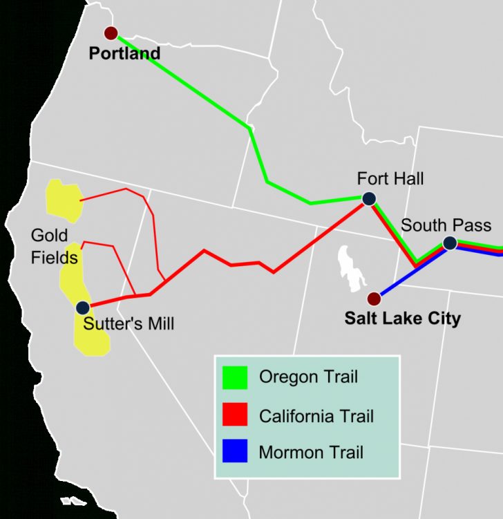