We set off on a camping trip to the coast today, spending the morning packing up and then leaving Corvallis right after lunch. It was a sunny 91 degrees in the Valley and the coast promised to be different. And indeed it was. When we stopped at a pull-out on the coast highway near Heceta Head, the world seemed dark and damp.
Our campsite was just a few miles south of Heceta. It was also half a mile inland, far enough to be out of the mist and into the sun. It was still damp, though, and not particularly warm.
Here’s a photo of E at 4:30 in the afternoon trying to warm up by moving her chair into a patch of sunlight.
We had a new piece of gear to try out, the mosquito net tent extension that we got from China via Quebec. There were no assembly instructions, but M had watched a video and brought along some extra bungee cords. So we managed to get it up. This is not quite how it’s supposed to look, but it’s close.
A full height zipper in the side wall allows for entrance and exit. The roof of the tent is supposed to be flat–the front edge is meant to be pushed up by the rear hatch on the truck. But our hatch has some sharp edges, so we won’t get the full effect until we fashion a bit of padding to protect the top fabric.
Tuesday, August 26th
After shivering through a breakfast of granola bars and toast, we drove back north a few miles along the coast and hiked up the Cummins Creek Trail. It’s a lovely walk through mature forest of hemlock, fir and red cedar. If you look carefully, you can see that the trail mostly follows a long abandoned road. We didn’t do the whole upper loop as that would have made for a total of seven miles, too much for us these days. We just walked up a mile or two, lunched on tuna sandwiches and then started back.
At that point we needed a little civilization, so we went to the Green Tortoise coffee place in Yachats, arriving just before closing time. After that it was back to the campsite, where we re-attached our truck tent and started to think about dinner. By dinnertime, we were getting a brisk on-shore breeze, damp and coldish. We bundled ourselves up in all our layers and ate some hot chili. We then went to bed early to keep warm but later found ourselves wide awake at midnight. To cure our insomnia we went for a midnight walk through the dim and quiet campground. To our surprise the wind had stopped and the temperature was much warmer than in the daytime, so it was a very pleasant time to walk.
Wednesday, August 27th
This morning we broke camp and started the trip home. On the way, we stopped at the Cape Perpetua visitors center. There are lots of interesting displays there, including a few bits and pieces about the people who originally lived in the area. Next to a display of native style baskets, there was a description of what happened when a basket maker agreed to give a class on how to make baskets. Here’s a description of the first few weeks of the class:
We also walked a one mile trail from the Visitor’s Center to the site of a very large Sitka Spruce. This one is estimated to be about 500 years old. Sitka Spruces only grow within 50 miles of the ocean, but that narrow strip of habitat extends from southeastern Alaska all the way down to Northern California.
The wood from a Sitka spruce is strong but lightweight, which made it very useful for building early airplanes. The Wright Brothers’ Flyer was built from spruce, as were the majority of airplanes prior to World War Two. (The Spruce Goose, however, was actually made of birch.) Spruce wood is also an excellent conductor of sound and is widely used to make musical instruments such as pianos, harps, guitars, and violins.
Wednesday, September 3rd
Today we drove up north a ways, stopping at the Woodburn Outlet Mall. In the Panera restaurant parking lot, we met up with a fellow named Roman, who owns a 550 HP Jaguar F-Type R and was looking for a nice car cover for it. For a nominal fee, the Chambeck Buyer Assistance Service was able to supply one.
We then had lunch at Panera. This Panera was kind of different. It had only self service kiosk style ordering, which meant that when we came in we didn’t see any humans anywhere. When we looked around the corner into the dining area, we could that there were a few customers; but considering that it was lunchtime, it didn’t seem like there were very many. There were employees present; you could hear them chatting somewhere in the back. And whenever one of the few diners finished and started to leave, a human would appear immediately and whisk away the dishes. It was a little eerie.
Just by coincidence (!) there happened to be a See’s Candy shop on the other side of the Panera parking lot. Inside that place, we had considerably more human interaction than we’d had at Panera. After that, we set off for our main destination: The Erratic Rock State Natural Site. The rock that this site honors currently sits atop a hill in the middle of an agricultural area just west of McMinneville, Oregon; but scientists say that it is originally from Canada, at least 500 miles away. It is estimated to weigh about 80,000 pounds.
The rock is argillite, a sedimentary rock that was formed on a sea floor about 600 million years ago. This is the only argillite ever found outside of Canada.
At some point during the last ice age, this large piece of rock was captured by a glacier and spent a few thousand years encased in ice. But then, as the last ice age started winding down, a whole lot of the ice age ice started to melt. The meltwater had nowhere to go because some remaining ice had created a dam thousands of feet high. At that point the ice surrounding the rock stopped being part of a glacier and instead became a large iceberg floating around in a very, very big lake of really cold water. But not quite cold enough. Eventually the ice dam broke and 50 cubic miles of water and ice rushed south. The resultant flow was up to 1,000 feet deep, more than powerful enough to carry along a small army of icebergs, including one that contained a certain big piece of rock. The flood flowed south for a hundred miles or so and then turned right* to head west down the Columbia Gorge. Then, at the mouth of the Willamette, it turned left* and flowed south again for 150 miles or so. Our rock, however, didn’t make it quite that far. Just forty miles south of what is now Portland, the iceberg with the big rock in it ran aground on a hill. And now the only trace of that iceberg is the rock it left behind.
Over the years, thousands of souvenir hunters have chipped away at the rock. Authorities estimate that several tons of stone have been removed.
*How, you might ask, did the flood know where to turn right and then later where to turn left? That’s a profound question and hard to answer, especially since they didn’t have any GPS at all back then. But if you asked the flood, it would probably say: I just go with the flow.
Thursday, September 4th
Another meeting of the Lemon Meringue Pie Society took place today. This was a traditional gathering in that it featured an actual lemon meringue pie, this one having been produced in-house by Chambeck Enterprises. All six members attended and each brought a healthy and delicious contribution to a potluck dinner preceding the pie.
We had a great time today attending an open house at the OSU College of Veterinary Medicine. It started at 5:30 PM in the parking lot of the Small Animal Hospital. The lot was closed to allow about 100 attendees to gather. We arrived at the registration table about ten minutes early and were assigned to a tour group. H and T were with there with us and we all got into Group 3. At 5:30 sharp the event commenced. First came the ice cream. This was OSU College of Agriculture ice cream from the newly reopened OSU Classic Creamery. It was served from a bright orange OSU food truck. Here’s the flavor board:
That first one is Beaver Bark — Vanilla base with choc flakes dyed for Beaver pride.
While the ice cream line moved along, the dean of the college welcomed us and gave a short history of the college, especially the small animal section. She recounted the story of how in the first years of its history the OSU Vet School offered only a two-year program that covered large animals only. In order to get a DVM degree, Oregon vet students had to spend two years in Corvallis and then transfer to Washington State for two more. It was only in the mid 2000s that the OSU small animal center was established. We already knew this story, of course, since our very own A was a member of the first graduating class to have done all four years of their program in Corvallis.
The welcome speeches were short and we were still finishing our ice cream when our tour leader led us into the building. (Free ice cream and short speeches…you can tell that these are smart people.) The tour took about an hour and a half. Our group stopped at nine different locations and heard a ten-minute presentation at each one. We got presentations about cardiology, oncology, orthopedics, anesthesia, laparoscopic surgery, diagnostic imaging, large animal surgery, the small animal emergency room, and the small animal rehabilitation center. We got to see a lot of expensive equipment and also a number of training devices that help vet students learn. One of these was the “high fidelity” electronic dog shown below. The dog breathes in and out–students can see the chest expand and hear the breaths. The dog also has a heartbeat–students can feel for a pulse just as they would on a real dog. The big video monitor displays various vital signs just as it would for a real animal.
Here, a senior lab instructor is explaining how the training dog is used. She can, for example, slow the dog’s breathing rate to mimic an animal that is unable to breathe on its own. Students can then save the dog using the same breathing assist procedures on the model as they would use on a real animal. Similarly, if the training dog’s heart stops beating, students can apply CPR. If they do it correctly, the heartbeat starts up again.
Below is a picture of the large animal surgery. The operating table uses a hydraulic system to raise and lower the height of the table as well as to provide various degrees of tilt. It can support draft horses weighing up to 2,000 pounds.
In the foreground you can see part of the chain hoist system that is used to lift the horse onto and off of the table.
We very much enjoyed seeing the animal hospital. The tour (and possibly the ice cream) energized us enough that when we got home we finally finished putting Gertrudis together.
Thursday, August 15th
Our friends K and L had us over for dinner and we had a delicious summertime meal, which was followed by one of E’s blackberry pies. The hours flew by. K, whose real name is R, has known M since both were sophomores at the U of U in Salt Lake City.
Saturday, August 16h
We went to a presentation about using native plants to support local birds, pollinators, and animals. It was given by two young women, both of whom run small businesses that help customers apply the ideas of people like Douglas Tallamy and Robin Wall Kimmerer. Although their presentation was overlong, their love for what they were doing was obvious and they were very knowledgable. We were so inspired that we wanted to run home immediately and start digging up grass and replacing it with kinnikinnik, wild iris and all that other stuff.
The presentation was up in Independence, Oregon, which happens to be right close to Monmouth, Oregon, which happens to have a Burgerville, which is the place that serves those wonderful Walla Walla onion rings–but only during the harvest season, which happens to end tomorrow! So, you can understand what we decided to do about lunch. The grass digging could wait.
Sunday, August 17th
We drove up to Beaverton today and had a late breakfast at a place called Tous Les Jours. We each had a pastry and also shared a “pecan croissant flattie.” The flattie wasn’t exactly a pastry…more like candy. Later in the day. we didn’t feel all that good, but breakfast was fun!
Somebody got into the flattie before we could even take its picture.
We’d never heard of Tous Les Jours, which turns out to have more than 1,500 locations worldwide. The franchise is owned by a South Korean company called CJ Foodville.
Since we happened to be up there in Beaverton, we decided to drive a few blocks down Canyon Road and pick up our new car, a Kia EV6. It is electric and has the same underpinnings as our old IONIQ 5. Here’s a photo of our first glimpse of it. It had just arrived at the dealership two days before.
Thursday, August 21st
So far we’ve managed to set our favorite radio stations, individual seating positions, and charging maximums. We also know, sort of, how to use the climate control, operate the sun roof and listen to our complimentary three months of Sirius XM. The EV6 is not as spacious inside as our Ioniq 5, but on the other hand it has a 120v outlet in the backseat, so we can put a microwave back there and make popcorn…or something. It can also back itself into the garage…provided someone keeps a firm hold on the proper button on the key fob.
After talking to various people at UPS, we finally got an explanation of our $140.50 package delivery fee. It all started when we were looking on the internet and saw a camping canopy that was made to extend out from the back of a vehicle. We thought it would be great to use with our little truck. So we went ahead and ordered it. The people who sell the canopy are in Quebec, Canada. We noticed that, of course, but we didn’t really think about it.
When the package entered the U.S., it had to go through Customs. Customs determined that although the item was sold by a Canadian company, it was manufactured in China. Therefore it was subject to an import tax based on the tariff level for China. We were subject to this fee because we were the ones who were actually importing the canopy into the United States. In order to move things along, UPS paid this fee for us. The Customs office then released the package and it continued on its way. At the time this happened, we were still in a state of blissful ignorance.
When the package arrived in Corvallis, our UPS driver left us a form that said we needed to pay a fee of $140.50 before he could deliver the package. Since we didn’t know what this was, E talked to both a local UPS rep and the UPS International Section. She found out enough to know that the charges were legitimate. We were told that we could pay the fee at the UPS website. After we did that, the package was delivered the next day.
We put down a deposit on a new car today. Yikes! Seems like an awfully big step. The car isn’t here yet; it is expected to arrive in Oregon on the 18th. Point of origin: West Point, Georgia.
Thursday, August 5th
Tis the season for Walla Walla onion rings and one of the best places to get them around here is at Burgerville. So we had our dinner there today in company with T and H. In yet another major development in the automotive world, T has a new RAV-4! It’s a beauty.
Saturday, August 9th
Beautiful full moon these last couple of days. Last night it shone through all our south facing windows like a spotlight. It makes it a little hard to sleep.
Our neighbor K passed away a few weeks ago. She and her husband had lived in the same house for many years, almost since the area was developed in the sixties. We got to know her a little after we arrived in the neighborhood. She’d been a school librarian. Her husband had passed away some time ago and you could tell she missed him.
A few years ago she told us that a long time ago they had enlarged their garage by adding an extension onto the back. She said there were still three cars in there. Lately her children have been coming around to do the sort of thing one does after a death. Last week they took the cars out of the garage and parked them side by side in the oversized driveway. Turns out they are all Ford Galaxies from the years 1962-64.
All the same vintage, but three different body styles. On the left a station wagon, on the right a four-door sedan, and in the center a two-door coupe. Ford’s model name for the coupe was the Galaxy Fastback.
K stopped driving two or three years ago, but before that we’d occasionally see her backing carefully out of the garage and then making her stately way off down the street. Which one of these cars did she drive? The coupe, of course. She’d earned it.
Sunday, August 10th
They said it was going to be hot today, so we took an early morning walk in the forest to avoid the worst of it. A lot of other folks were doing the same. The heat came in the afternoon. By 3:00 PM it was 97, by 6:00 it was 99. We’re supposed to see more of the same tomorrow and the next day.
Tuesday, August 12th
Today we received a letter from UPS which provided a breakdown of the total cost of our importing adventure. The import duty amount was $118.53 plus a processing fee of $2.62. UPS paid those directly to the U.S. Customs Service. USP also charged us brokerage fees totaling $19.35. That all adds up to $140.50.
And one last thing. In researching this we learned the answer to something else that had puzzled us. Tariffs are much in the news these days, but they are not a new thing. The U.S. has always had some level of tariffs. So why have we never had to pay these charges before? That is because of a rule change. In the past there was a rule called ‘de minimus.’ It said that individual packages that were valued at under $800 would be exempt from customs charges. But that rule is being phased out. Several months ago the government announced that the de minimus rule would no longer apply to imports from China. Then, just a couple of weeks ago, the government announced that the de minimus exemption will be phased out entirely for all countries starting on August 29 of this year.
Would we have purchased the truck tent if we had foreseen all of this? Probably not. But we have it now and can’t wait to try it out. It’s sure to disappoint a lot of mosquitoes who are looking for a snack. We have a campsite reserved.
We drove our friend P down to Springfield today. Her 20-year-old Volvo was on its last legs and she had been looking for a new car. She wanted a Toyota Corolla Cross, a small SUV that is available either as a gasoline car or as a hybrid. The Corvallis Toyota dealer had one on the lot, and it was a nice shade of green. But it was a gasoline only car and P wanted a hybrid. The hybrid version, though, is much in demand right now. The dealership could order one for her, but it wouldn’t come for a month or two. The Volvo wasn’t going to last that long.
When we heard about this problem, we immediately put her in touch with the Chambeck Buyer Assistance Service–a shadowy group whose origins and ultimate purposes are almost completely unknown to the general public. They suggested that she travel to the Washington, DC area and take a look at a green Lamborghini Urus.
P said that although she liked the Urus very much, it was the wrong shade of green. CBAS then went to Plan B and offered to drive her to the Springfield, Oregon area, where a local dealer had two Corolla Cross Hybrids on offer, both of them lightly used 2024 models. So off we went this morning, venturing deep into the southernmost parts of Springfield, where we had never gone before. At the dealership two salespeople assisted us, which was a little strange, but both were nice–laid back and not constantly chattering. We took a test drive (unaccompanied by a salesperson!), asked a few questions and then adjourned for lunch at a place called Plank Town. After a bit of strategizing, we went back to the car store to talk about price. How did that go? Well…just a little while later, M and E were driving back to Corvallis by themselves.
Sunday, August 3rd
We were on the road again today, going to Portland for a mild version of a night on the town. We got to the city at about 4:00 and checked into the Royal Sonesta Hotel. The hotel is located on Fifth between Washington and Alder, a part of the old downtown whose best days lie a few years in the past. (Just across Alder sits the huge cream colored building that was once the Meier and Frank flagship.) The building that the Royal Sonesta occupies is a beautiful old property that has been home to a succession of hotels over the years. We first stayed there years ago, when our friend J recommended it during its time as the Fifth Avenue Suites.
The Royal Sonesta gets the ‘royal’ part of its name because the building is the ancestral home of the Viscount of Portland, whose portrait is above.
For us, the hotel had two other advantages: it wasn’t very expensive and it was close to Huber’s. Huber’s is a bar and restaurant that E had heard of and wanted to experience. It is located on Third between Washington and Harvey Milk, an area whose best days lie even farther in the past.
Huber’s claims to be Portland’s oldest restaurant, having begun life as the Bureau Saloon in 1879. A few years later the Bureau was bought by a man named Frank Huber, who gave it the name it still bears. In 1910 Huber moved the business into the newly completed Oregon Pioneer Building, where it has remained ever since. Frank Huber himself tended the bar. In the kitchen, a talented cook became famous for his roast turkey dinners. This cook, whose Americanized name was Jim Louie, was a Chinese immigrant who had come to America as an 11-year-old stowaway on a ship from Guangdong.
In 1911, when Frank Huber died, his widow Augusta hired Jim Louie to manage the restaurant. Jim took over the bartending while also keeping an eye on the turkey roasting. During Prohibition the bar shelves were empty, but the restaurant side of the business remained very successful, partly because your meal could include one of Huber’s legendary Manhattans delivered to your table in a coffee mug. When Augusta died in 1940, her son John allowed Jim Louie to purchase a half interest in the business for the sum of one dollar.
The Oregon Pioneer Building
E took this shot of one section of the old building, just a few yards from the entrance that leads eventually to Huber’s.
For dinner we shared crab cakes and a turkey dinner in honor of the old days. Plus, E sampled Huber’s famous Spanish coffee, which combines coffee with Kahlua, 151 proof rum, and triple sec. The drink is mixed at your table in an extravagant presentation that involves two different colored flames–one blue and one red. The end result is delicious.
The pouring of the Kahlua douses the blue flame. The coffee pour puts out the red flames before a layer of frothy cream finishes things off.
There wasn’t much of E’s coffee left at this point. (But there was still some sugar on the rim.)
Huber’s is situated right in the center the Pioneer building and thus has no windows. It does have a wonderful stained glass skylight that dates from the original construction in 1910
Monday, August 4th
Today we went up to the Clark County Fair in Ridgefield, Washington and said hello to A. He’s up there with his food truck serving Nachos for Dessert and selling cold drinks. We indulged in our favorites, for E a Nacho S’more and for M a Cookies and Cream. While we were there, we walked through the chicken hall, looked at some prize-winning baked goods, and rode one of the ferris wheels. The Clark County fair is a big one, considerably larger than the Benton County version.
When we finally got back home to Corvallis, we found a note on our door from UPS. It said that they had tried to deliver a package that included COD charges. This was strange; we knew we hadn’t ordered anything COD. Was COD even a thing anymore? We found out that in order to get our $350 item for which the vendor had already been paid, UPS needed us to pay an additional $140 for something or other. Can we all guess what that was? (There’s a clue on the label below.)
Back when M was a child of twenty, he used to prepare for his backpacking adventures by baking cookies. They were hefty cookies–chocolate chip with butter, extra flour, lots of oats, and a little bit of wheat germ. He figured that if he took enough of these with him, along with some jerky and a few teabags, he would have a sufficiency of food. Nowadays when he goes camping with E, his diet includes others things–strange alien foods like carrots and lettuce and celery and oranges, plus the occasional masoor dahl chicken. However, there is still something to be said for cookies.
Having packed up our cookies and things, we left Corvallis at ten this morning. We drove north to Portland and then east up the Columbia River gorge. Thirty minutes from Troutdale we crossed the so-called Bridge of the Gods over to the Washington side. We gassed up in Stevenson, Washington. (Yes, we took a gas powered vehicle. Not many chargers available in the forest.)
The riverboat dock at the port of Stevenson. We ate our lunch at the dockside park.
At Carson, Washington we turned north, away from the river and up into the forests of the Washington Cascades. At around 2:00 in the afternoon, we stopped at a campground called Paradise Creek, where we were hoping to find an open spot. We knew that all the reservable spots would have long been taken. But we also knew that the campground had twelve first come first serve places (FCFS’s). We had planned our trip to get us there early enough in the day to maybe snag one. And it turned out that there were three open spots; we picked one and felt very much relieved.
The Paradise Creek campground turned out to be amazing. The campsites are all situated within a large stand of old growth trees: huge firs and cedars with trunks more than six feet across and crowns so high that it hurts your neck to see them.
When dinner time came, we realized that we had forgotten to bring certain key elements of our planned meal. So we had lettuce and mayonnaise sandwich made on pan fried hamburger buns. To accompany this, we chose to share a canned Cuervo margarita, nicely chilled. When it was time for dessert, we found that we had brought along quite a number of cookies. Later, E had her first experience sleeping in the back of the truck. It was very comfortable, she reports, but also claustrophobic.
Monday, July 21st
Our goal for Day 2 was to reach a place called Windy Ridge, where there were supposed to be some fine views of the Mt. St. Helens area. This wasn’t going to be easy, however, because we had found out just before we left Corvallis that the road we planned to take had been closed by a landslide. We had sketched out a detour, but it was long and complicated. You can see it on the right hand map below. The left hand map shows the route we had originally planned.
We started out at 8:30, making good time on a wide two lane road. Soon we came to a sign that told us to turn left to go to Windy Ridge. Sadly, another sign just beside it indicated that the route was actually closed, as we had suspected. At that point, the great detour adventure began. M drove while E kept track of our progress in our Benchmark Washington Road and Recreation Atlas. The views along the way started out nice and soon got even nicer. The roads, of course, got worse, becoming narrower and narrower and also turning to gravel. Fortunately, some of the critical road junctions had signage that helped us choose our turns. Also our atlas was excellent, so we never got lost. But there was no way to make the drive any shorter or the roads any smoother.
Finally, after about four hours, we got to a place where we knew we were heading straight for Windy Ridge and that we were probably not much more than an hour away. That was when we ran into road construction. Yup, road construction high in the mountains and deep in the forest. We stopped behind three other vehicles and noticed that the occupants were mostly out of their cars, either walking around or sitting in the middle of the road chewing the fat. We asked one fellow what was going on and found out we could expect a delay of at least twenty minutes. Great. On the other hand, it was 12:30; so we broke out our peanut butter and jelly sandwiches, Kettle chips, and little cans of juice and had a picnic on the shoulder of the road. After lunch we started the last leg of our journey. A half hour later we got our first glimpse of Mount St. Helens. Though the mountain was still many miles away, the slopes around us showed signs of the destruction that occurred forty-five years ago. The area is thick with trees, but the living trees are uniformly young. Only a few gray-white ghost trees remain from the 1980 forest. The ghosts are trees that were killed by the blast but not blown down.
Mount St. Helens is in the background, its peak hidden in the clouds. In the middle distance, where the blast wave was stronger, ghost trees are rare. At that distance everything was flattened.
Back in May of 1980, in the weeks before the eruption, it became clear that something big was about to happen. Authorities first ordered the evacuation of an area within four miles of the mountain. That was called the red zone and contained a popular recreation area that held lodges, campgrounds, and youth camps. In addition to the red zone, officials also established a blue zone. This was a larger circle that extended fifty miles in every direction from the mountain. Evacuation was ordered for the blue zone also, but this was considered by some to be a ridiculous excess of caution. As a kind of compromise, evacuees were allowed to re-enter the blue zone temporarily if they could show good cause. When the mountain erupted, the lodges and camps in the red zone were all empty and only two people died. Within the blue zone, fifty-four people were killed.
Just before the eruption, a couple who owned a mine in the blue zone got permission to enter. They took their nephew along with them. They drove up to Windy Ridge, parked beside the highway, and hiked eight miles up to the mine. When the mountain exploded, all three were killed. Back down by the road, the remains of their 1974 Pontiac Grand Prix have been preserved as a monument.
The mountain loomed larger as we got closer.
This is part of what they call the pumice plain. It lies at the foot of the northwest side of the mountain and covers the site of the old Spirit Lake, where the campgrounds and lodges were located. Since pumice is very low in plant nutrients, scientists did not expect even this level of natural recovery after only forty-five years.
The eruption knocked down millions of trees. When the new Spirit Lake was forming, hundreds of such trees ended up floating on its surface. The white patch that you see here is what remains of the great Spirit Lake log mat.
We took this photo as we were leaving. The clouds had lifted quite a bit and we could almost see the top. It’s still a big mountain, but it’s not what it was.
By the time we had viewed all we wanted to view it was 3:00 in the afternoon and we were tired. We had no time to rest though, as we had at least two more hours of driving before we reached our next planned stop: a motel in the town of Morton. Morton wasn’t all that far away, but for much of the route a person didn’t want to go more than 30 mph. Only on the last stretch could E put the pedal to the metal. We rolled into town at 5:00.
Tuesday, July 22nd
In the morning we drove Hwy 12 west to I-5 and took the sensible route home, making just one stop. At Bridgeport Village we had coffee and a sandwich at Peet’s and also dropped into REI. That was necessary because E had some patronage credit that she was itching to spend. She got some new sunglasses and a lightweight summer blouse. Also a new pair of hiking shorts for M. It was, after all, his birthday.
Wednesday, July 23rd
E had lunch with her THEPAJ group at Tarntip. When the family that owns Tarntip first came to town– lo, those many years ago–two sisters came to study with us at the English Language Institute. Today K took the time to come out from the kitchen and chat with the group. Very nice.
Friday, July 25th
Wonderful weather today, not too hot. This was good since we’d planned to go hiking. After getting back from that excursion, we had a quick dinner and then went to hear some live music. It was Celtic Festival weekend in Corvallis and the headline musical performance was by a group called Open the Door for Three. The three were a fiddler, an uilleann piper, and a bouzouki player/vocalist. They were very good. The concert was at PRAX, where we had never been, so that was also part of the fun.
Saturday, July 26th
In the morning we visited the Saturday Market to see another Celtic Festival event: a free performance by a marching bagpipe band. While we were there, we bought some blackberries. Later in the day, we drove the Road Shark up to Salem, where the Andees met us for dinner at the India Palace. M got another b-day present, a jigsaw version of a portrait of Gertrudis Gomez de Avellaneda by Federico Madrazo. It was a lovely second birthday dinner. M also also enjoyed the drive to and from Salem. He is still learning about the little Beamer, so on the way home, when it started to get dark, he had to pull over and spend some time figuring out how to turn the lights on.
We went down to Eugene today. E wanted to visit the Lululemon store there. Strangely enough, the shop is just across the street from the Euphoria Chocolate shop, which is just two doors away from a very nice Thai restaurant. What a serendipitous non-coincidence! On our way back to Corvallis, we stopped at Peoria Gardens, a big wholesale nursery. E had just found out that for two weeks a year Peoria Gardens opens to the public and that this was one of those weeks. We wanted to check it out.
Hot weather seems to have settled in pretty good around here, so maybe this is not the best time to be adding new plants. But the prices! We ended up getting three plants for just $21. Now, do we have the strength to get them into the ground?
Saturday, July 12th
Well… E struck first, getting her new sunflower planted early this morning. Two more to go.
Later in the morning, we went to an event put on by the Letitia Carson Legacy Project out on Tampico Road, just north of Corvallis. The LCLP is jointly sponsored by Oregon Black Pioneers, Oregon State University, Black Oregon Land Trust, and Linn-Benton NAACP. Carson was a farmer and homesteader who first came to the Corvallis area in 1849 and hers is quite a story. She was born into slavery in Kentucky around 1816. By September of 1844 she was living in Missouri with a man named David Carson, a naturalized Irish immigrant and the father of her unborn child. In the Spring of 1845 the two joined a large group of immigrants on a journey from Missouri to Oregon. Their daughter Martha was born in June of 1945 as they were crossing Nebraska. In late 1845 they reached Oregon and David filed a homestead claim for 640 acres in Benton County just north of Corvallis. They built a house on the land in the spring of 1846.
The Carson land claim is now a part of Oregon State University and is managed by the Department of Animal and Rangeland Science. One way in which the University supports the LCLP is by giving permission to hold outreach events in an area that is normally closed to the public. When we arrived, the pasture gate was open and cars were parked on the grass. We met our hosts and the other tour members under a canopy, signed our waivers, and set off for a two-mile walk. Our guide led us out of the pasture and into a riparian area of large trees and thick understory on the banks of Soap Creek. The project had recently created a path through this area leading to the site of the Carson residence. The path begins at a place where some young trees have formed a kind of archway.
Our guide, seen here in the center, called this the Fairy Portal. We liked her right away.
On its way to the homesite, the trail passes a number of large fruit trees which have been long untended. The oldest of these is this huge pear three that is estimated to be around 200 years old. It is possible that the Carsons walked past this tree when it was a youngster.
There were a number of other large apple and cherry trees in the area, all growing wild. They are not nearly as old as the pear, but they are almost certainly descended from trees planted by early settlers. At the same time, the area hosts an array of native plants including large oak, maple and ash trees, as well as many types of understory plants, some of which are also growing in our back yard. Unlike our yard, however, this small area is real wild land, settled 175 years ago but neglected for the last hundred or so.
Nothing remains of the Carson House; but the trail does take you to the spot where the house probably stood, right where E is walking in the photo below. Just behind the main mass of foliage in the picture, there is a year round stream, which would have been their water source.
None of the current trees are old enough to have been present back when the house was here, but they are likely the descendants of trees that were there.
The meadowland portion of the Carson claim was located immediately to the east of the homesite, so they would have been able to keep an eye on their stock. Nowadays–one hundred and seventy-five years later–there are still cows pastured where theirs were, as the area is part of the range of OSU’s Cattle Research Herd.
The Carson homestead seems to have thrived for a time and in September of 1849, they had another child, this time a son. In 1852, however, David Carson fell ill and died. Letitia’s status at this point was unclear. As Zachary Stocks puts in his Oregon Encyclopedia article, “While Letitia was likely Carson’s slave at some point, she would later claim to have been his free domestic servant and identified as his widow after his death.”
Upon David’s death, Benton County authorities determined that Letitia had no right of inheritance or any other claim to the property, which left her and her two children homeless. The land and goods were auctioned off and the proceeds were distributed to David Carson’s relatives in North Carolina. But that was far from the end of the story. First, we know that Letitia attended the auction and paid $104.87 to buy back what she could of her own possessions: a washtub, a pot, a skillet and lid, six plates, a bed and bedding, two cows, and a calf. Next, she joined another group of settlers headed for another land claim area, this time in Douglas County, 160 miles to the south.
In 1854, while living in Douglas County, she engaged a Corvallis lawyer and filed a lawsuit seeking damages for her losses in Benton County. The suit went to trial and ended with a hung jury. The case was then retried. In the second trial twelve white male jurors unanimously found in her favor and awarded her damages. There was then a third trial concerning the separate matter of who owned the Carson’s herd of 34 cattle. During this trial a neighbor testified that David Carson himself, in the year before his death, had stated that “only seven of cattle were his and the rest belonged to Letitia.” All told, Letitia Carson was awarded $1500 plus $230 in court costs.
In 1863 Carson filed her own homestead claim on a 160 acre tract near her new home in Douglas County. In 1869, after making the required improvements, she applied for and received certification of her claim. She is the only known black woman to have accomplished this in Oregon. Her story was the inspiration for Jane Kirkpatrick’s 2014 novel A Light In The Wilderness. Carson died in 1888, leaving her land to her son. Her daughter, Martha, married a French-Walla Walla man named Narcisse Lavadour with whom she had seven children.
Sunday, July 13th
This time it is M who gets up early and puts his hebe plant into the ground.
Monday, July 14th
And finally E and M join forces to plant the last of their purchases, a Russian sage. M digs the hole and E plunks in the plant.
Wednesday, July 16th
Having completed the purchase of the frivolous toy car, we must now move on to the serious real car. The lease on our Ioniq 5 expires next month. It has been a wonderful car and our lease agreement has a buy-out option. So we could just keep it. But the buy-out price specified in the lease agreement is higher than the price of several identical 2023 Ioniq 5‘s that we currently see advertised in the used car market–about $10,000 higher. We love the car, but don’t love it that much. So we need to make a change. What shall we do? Go back to a gasoline or gasoline/hybrid car? Not a tinker’s chance. Lease a new Ioniq? Buy one? Maybe.
So today we went car shopping, starting out early in the morning because the forecast was for a highs in the mid nineties. We got to Beaverton around ten and went to check out a Kia EV-6. Nice. Very nice. Then we headed back south to Salem to check out what the newest Ioniq 5 is like. On the way we stopped at a rest area and had our lunch– dry roasted peanuts, generous portions of nicely chilled gazpacho, and two pieces of chocolate. This got us ready for the next dealership.
Which was Withnell’s in Salem, where we looked at the newestIoniq-5’s. They’re nice too, both the dealership and the car. The only great flaw in the 2023 model was the lack of a wiper for the rear window. For 2025, that lack has been remedied. So now we have a lot to think about. Both the EV6 and the Ioniq 5 are made in the U.S. and thus currently qualify for the $7,500 tax credit, so that’s a wash.
Thursday, July 17th
We had a number of responses to the question of whether or not to keep the BMW’s RDSHARK license plates. All were in favor. And that’s how it’s going to be.
This is a 25 year old car and has 92,000 miles on it, but looks awfully good under the hood. The previous owner did a lot of work. All the hoses are new and all the old brake lines have been replaced by new steel ones. The radiator and radiator fan, which are known weak points on these cars, have been replaced with better than original parts. Also note the lovely reinforcing bar running across the top of the engine between the strut towers. The bar is original but must have had its surface refinished at some point. The engine is a straight six (not a V6) and was originally designed for larger BMW models. It is too tall fit under the hood of this car, so it has been mounted slightly at a slant.
The color plaque is on the driver’s side strut tower. The car was made at the BMW factory in Spartanburg, South Carolina, but this bit is very German. The color is Imola Red, Imola being a legendary Italian racetrack.
The seats have also been refurbished recently. The interior fits two people comfortably, but they can’t bring very much with them as there is just about zero extra space. The car has a five speed manual transmission and goes like stink.
But there is some space in the trunk. Right now part of it is taken up by a folded set of BMW brand luggage designed especially to fit the shape of this trunk. There are also three storage pouches on the underside of the trunk lid.
Inside the trunk, on the right side, the previous owner installed this extra piece that he most likely made himself. It provides a bracket to hold a fire extinguisher–just in case you get into a road rage incident involving molotov cocktails–and also gives him a place to mount some extra sharkiness.
Friday, July 18th
We called the Kia dealer in Beaverton and asked about our chances o get a blue EV6. Our salesperson said he’d check and get back to us. What he found was that there were no blue ones available for dealer swap anywhere in the Northwest. But…he said that his very dealership has a blue one on order. It is expected to arrive in the first week of September. Hm. That wouldn’t be too bad. The new car would arrive two weeks after we turn in our old one, but we maybe we could deal with that. E could cruise around in the truck, leaving M stuck with the Shark. Or vice versa. (In the immortal words of La Botanica, “Step on it, Ev!”)
Saturday, July 19th
But enough about cars. Tomorrow we’re going camping. It’s taking us a while to get ready. Must focus!
We went up to Portland today and shopped at the Columbia Sportswear Employee store. Our friend J had given E a one-time pass to go in and buy stuff for the same price that Columbia employees pay. E got a fleece jacket and some pants that she needed while M got a jacket and a pair of hiking pants that he sorta, maybe needed.
All prices in the store are 40% or 50% off. Off of what exactly? That’s hard to say. They have a great selection though, and we had a good time.
We also had fun at our next stop: Kitchen Kaboodle, a venerable kitchen/home store that we hadn’t visited in years. We got some new cotton napkins and E got herself an apron. On our way home we stopped at our favorite shoe store at Bridgeport Village. No luck there, but we were tired. Three things in one day are probably too much for us old folks.
Wednesday, July 2nd
M’s Jaguar F-Type has been gone for a couple weeks now, having been sold down the river to Carmax. It was a wonderful car–fast, luxurious, and reliable. We both loved it. So why is it gone? Mostly because this seems to be M’s pattern. (E comments that she’s glad M doesn’t change wives as often as he changes cars.) In this case, one of his rationales was that the Jag didn’t really fit in the garage and had to be stored offsite at considerable expense. Also, its very expensive tires were not getting any younger. And, its very expensive brakes were giving an occasional hint of a warped rotor somewhere.
So what’s next? We don’t know. Could M survive without a sports car for a while, maybe a long while? And what about E? If M didn’t have a nice car, would she have to dump him and look for a partner who could provide for her properly? That would be awkward.
So today, in an attempt to deal with the situation, M went up to Portland to look at Mazda Miatas. He’d had one before and liked it. In fact that was the car that he had when E married him. But what he found today was that the time for a Miata has passed. Yes, a Miata would fit into the garage. And no, a Miata is not too hard to get into and out of, even at our age. But the ride quality is for younger people. Plus it has almost no power at all. M sees no clear way forward.
Thursday, July 3rd
Tertulia at Coffee People with J, after which we went home and attacked the garden. The garden is having a visitor tomorrow and we’ve been trying to make it look presentable. Nice weather for gardening: sunny but cool with 60’s in the morning, 70’s in the afternoon.
Friday, July 4th
E’s friend B came over in the morning and had her garden tour. She came bearing gifts: two Aucoba japonica starts. These will join the ones we have in the shady back corner.
B is not in the picture, but her gifts (in the white bucket) have already arrived.
A real melange here, with native thimbleberry, salal, switchgrass, cascara and two kinds of mahonia sharing space with alien black mondo and Mexican orange.
The Mahonia is fruiting nicely. Those ‘Oregon grapes’ are tart but mostly safe to eat in small quantities. Not recommended for pregnant or nursing mothers.
Our best hydrangea year ever–which isn’t saying too much.
From left to right: crocosmia, raspberries, an almost invisible lilac, and clematis growing on ninebark. Shasta daisies.
Saturday, July 5th
Got the Aucobas into the ground.
Sunday, July 6th
Well! Oddly enough, the guy down the street has parked his little sports car out on his front lawn. It’s for sale.
The weather has turned hot. We only work in the garden early in the morning.
Monday, July 7th
Chores and shopping. We notice that the little car is gone from the owner’s front lawn. Sold already?
Tuesday, July 8th
Jam making day! E headed out to the Peoria farm market to get a flat of raspberries. On her way she noticed that the little car is back and is still for sale. She stopped at Bi-Mart and texted M to go check it out. When she got back, M said it was time for her to look at it too.
After that, E got on to the important work of making a couple of batches of jam–a total of fourteen and a half jars.
Meanwhile M occupied his time by poking around the Internet boning up on older BMW M cars and processing the lengthy history and features of this one:
Eventually he bought it because, you know, it fits in the garage. Also, the price was right.
The burning question now is whether to keep the previous owner’s custom license plates or replace them with something a little more subdued. Does anyone have any advice?
(This posting is part of the Road Trip series. Meandering on the Way will return soon.)
There’s a nice freeway that runs east/west through the state of Washington. If you were traveling west, you could start in Spokane, a town of 230,000 near the Idaho border, and pretty quickly end up in the Seattle area, where 3,581,000 people live near the shores of Puget Sound. That would be fine. But there are lots of other ways to cross the state. You could, for example, start in a Washington town called Pasco. That’s where M started in June of 2025.
In Pasco, M stayed at a Hampton Inn that was in the midst of transitioning into something else. He dined at a Mexican restaurant called Trejo’s, which was really good. In the morning he found Washington Hwy 124 and left Pasco heading east. Soon he found himself on a bridge crossing over the Snake River, just a mile north of where it flows into the Columbia. Oregonians tend to think of the Columbia as that big old thing that runs west across the top of the state until it finally reaches the Pacific Ocean. But at the place where the Snake flows into the Columbia, the Columbia is actually flowing southeast, which was something that M had not expected. However, as he himself was beginning his westward journey across Washington by heading east, he could hardly object if the Columbia was doing something similar. (More on that later.)
Since his first destination was Palouse Falls, he eventually turned off of 124 and took a small road northeast toward Clyde and Lyons Ferry. The route led him out the farming country he’d been seeing and into something…different.
The road to Lyons Ferry
When M got to Lyons Ferry he found that it doesn’t have a ferry anymore. But it is still the spot where the Palouse River flows into the Snake River. And it is quite a place, in its way. For one thing, there is a rather striking railroad bridge over the Snake just downstream from where the Palouse comes in.
The Snake is curving around on the left and the Palouse is entering from the right. The birds are just sitting there.
There’s also a highway bridge. At its north end there’s a nice state park down among the trees.
M crossed the highway bridge and found that the main road made a hard left. It then took him under the railroad bridge, which at that point looked like this:
From Lyons Ferry–the place of the two bridges–it’s just a few more miles to Palouse Falls State Park. To use the park, you have to display a Discover Washington recreation pass. Fortunately, M had bought such a pass. Less fortunately, he had forgotten to bring it. So he parked in the main lot anyway and hoped for the best. The place was mostly empty. Here’s his first glimpse of the falls.
And here’s the big picture:
Remember that railroad bridge at Lyons Ferry? That same rail line passes very near to Palouse Falls. M took the following photo from a little bridge where the Palouse State Park road crosses over the track. The falls are just a few hundred yards away.
Now that he’d seen the waterfall, it was time for M to get serious about his goal of traveling west. Naturally, his first step was to drive northeast. Sigh. But not for long. At a town called Washtucna (population 211, said to have been named for a prominent Palouse Native American) he turned left onto Hwy 126 and headed west. It was at about this time that the day started getting warmer, which was unfortunate because the air conditioning on M’s truck wasn’t working. The fan roared, but the air coming out of the vents was awfully warm. Great.
At this point M was aiming to get to the town of Othello, where he figured he could turn north and make a visit to a place called Drumheller Channels. It was only about 45 miles to Othello, but the temperature was up to 88. M drove with both windows slightly open to get some air circulation and to ameliorate the greenhouse effect. It was hot and noisy. He thought of the old days, a trip he’d taken with his family from Utah to Colorado in the early sixties. That had been a hot ride also–back in the days when cars didn’t have air conditioning. As far as M is concerned, we–as a society–should probably not go back to those days, at least not till things go truly bad.
From Othello it was just fifteen minutes to the Drumheller Channels National Natural Landmark. M had never before experienced anything called a National Natural Landmark. What was that supposed to be exactly? Well, here’s what it looked like from the viewpoint:
Hmm. M was not impressed. This landmark, whatever it was, just looked hot, dry and seriously lacking in shade. But, as it happens, there are some landmarks that you can only really see if you use your imagination. (And yes, that does mean that M had driven fifty miles through the heat just so he could visit an imaginary landmark, but bear with us.) The interesting thing about this landscape is the matter of how it came to exist–the past events that caused it to be what we see today.
There are in fact lots of places in Washington that are similar to this. The first person to study them and provide an explanation of how they were formed was an Univ. of Washington geologist named J Harlen Bretz. In the summer of 1922, Bretz became fascinated by the geology of the eastern part of the state. He saw that the landscape included what appeared to be very large potholes, ripples and water channels. These are the same features that are found today in rivers everywhere. The only difference was that the ones he was seeing in the landscape were up to a hundred times larger. He concluded that these channeled scablands–as they are now called–must have been created by one or more massive floods in the distant past. During the next few years Bretz published a series of papers on the topic, all of which were unanimously rejected by the Geology establishment, which was then dominated by Ivy League Geology departments.
Bretz stuck to his guns and forty years of academic debate ensued. During those years another geologist, Joseph Pardee, began publishing his findings concerning Glacial Lake Missoula. Pardee’s work provided more evidence in support of Bretz’s theories, as did analysis of satellite photos and other research in the 1970’s. In 1979, when Bretz was 96, he was awarded the Penrose Medal, the Geological Society of America’s highest honor. “All my enemies are dead,” he told his son, “so I have no one to gloat over.”
So…to properly appreciate the view at the Drumheller Channels National Natural Landmark, all you have to do is imagine that that there is a river flowing over this scene from left to right–a really big river, a river 500 feet deep and who knows how many miles wide. Let’s try looking at the photo again and this time adding in the river.
Of course if the river was 600 feet deep, we’d be standing here under 350 feet under water. So, to avoid our imaginary drowning, maybe we should move along.
When M left the Drumheller Scablands viewpoint, it was getting to be lunchtime. He had prepared himself a lunch before leaving Pasco. Now what he needed was some shady place where he could sit down and eat it. His best bet was to find a park in Othello (pop. 8,549). He ended up in Pioneer Park, which may not be the most pleasant park ever made. It is on the main highway through town and just half a block from another busy route. But…it had a picnic table in the shade and a lovely view of this USAF T-33 training aircraft. The T-33 was developed in the 1951 for the express purpose of teaching experienced propeller plane pilots how to fly jets.
Othello’s connection to the U.S. Air Force dates back to the cold war era. From 1951 to 1973, the 637th Radar Squadron was stationed just outside of town.
If you ever find yourself in downtown Othello, take a drive up North Broadway Avenue to the north end of town. That will take about a minute and a half. There you will see a half dozen or so large industrial buildings, some of which look like factories. M saw them as he drove through and wondered what they were making. Turns out it that pretty much everything in Othello is about potatoes. The industrial buildings are all either cold storage facilities or factories that make frozen potatoes. The complex in the north end of Othello is owned by a company called McCain. Another similar complex a few miles east of town is owned by Simplot. The production of these two facilities combined means that Othello processors account for 1.5 billion pounds of frozen potatoes annually, roughly 15% of all North American production. By coincidence, the small bag of Kettle chips that M had with his Pioneer Park lunch weighed exactly 1.5 ounces. They were delicious.
The day was advancing and M wasn’t even halfway across the state. It was time to get a move on. M got back in the truck and drove down South Broadway Ave till he could turn west onto Washington Hwy 24. This would take him across the top of a large arid plain called the Hanford Reach and then along to the city of Yakima. The Hanford Reach, as M saw it while driving across its northernmost section, looked like this.
At this point M was following Hwy 24 straight west through a portion of what is now the Hanford Reach National Monument. The Monument was created in 2000 and includes 325 square miles of land. Those 325 square miles had previously been part of a security buffer zone within the Hanford Nuclear Site. On the map below the jagged blue and gray line shows the extent of the original Hanford Nuclear Site. The gray areas are the land that was removed from the nuclear site in 2000 and turned into a National Monument. The white area in the center is the core of the original nuclear site and is now called the Dept. of Energy Hanford Reservation. It covers 586 square miles. The thick black line that runs from the upper left to lower right is the Columbia River. M’s route is shown in green.
You can see on the map that M crossed the Columbia River just a few miles west of a small gray square labelled B/C. M remembers crossing the river and noticing two things. First, how odd it was to again see the river flowing eastward and second, that it was a much smaller Columbia River than he was used to seeing. What he didn’t quite realize at that moment was how near he was to the site of the Hanford B and C nuclear reactors. Completed in 1944, Hanford B was the world’s first large scale plutonium production reactor. Hanford B produced plutonium for the world’s first atomic bomb–the test device that was detonated in New Mexico on July 16, 1945–and also for the bomb dropped on Nagasaki on August 9, 1945.
In the following years, seven more reactors were built on the south bank of the Columbia. All of them used river water for cooling. As the water passed through the reactors it became contaminated with radioactive isotopes of many elements and also with a number of toxic cleaning chemicals. When it left the reactor the water was directed into one of the more than one hundred “retention basins” where it was allowed to cool down from its 200 degree temperature. Retention time was “up to” six hours. Then, still quite warm, it was pumped back into the river. (See this article for details about the effects of this practice.) The Hanford reactor bank continued to produce weapons grade plutonium for the next 27 years..
Once past Hanford, Hwy 24 took M westward toward Yakima. He got there in mid afternoon and stopped only to get gas before taking Hwy 12 northwest into the foothills of the Cascades. Slowly but surely, as he climbed into the mountains, the temperature declined. Good. Before too long he reached the summit at White Pass and began descending down the west side of the mountains. The road was good but had only two lanes and was very curvy. The scenery made a nice change from that of the central and eastern parts of the state.
Shortly after he stopped to see the waterfall, as M was continuing down the mountain, going reasonably fast, he suddenly noticed a white car right behind him, very close behind him. It was some kind of exotic sports car, possibly a Lamborghini; he couldn’t really tell. Clearly the driver would like to pass. Just as clearly, what with all the constant curves, passing would not be safe. While M was stewing about this, another car came up close behind the white one. It was also an exotic, a Ferrari. Behind that appeared a red Porsche, and behind that several more vehicles of the same sort. M couldn’t see how many because of the curves in the road. He thought it must be some high end car club out on a run. They were probably based in Seattle and planned to loop back up that way when they were done with Hwy 12. M did not like being in the front of this particular group. It had been a long day and this was not something he had planned on dealing with.
After a few minutes and a few more curves, M realized that the experience was a little like driving the pace car at the beginning of the Indianapolis 500. The idea there is for the pace car to drive one lap of the raceway at a very moderate speed with all the real racing cars tucked in obediently behind. At the end of that one lap, the pace car darts quickly out of the way, the race drivers all hit the gas and the event begins. On this road, though, there was no place for M to pull over and get out of the way. But wait, maybe there was. What about that place? It was on the wrong side of the road but never mind. M turned on his left turn signal, hit the gas and quickly crossed over to the wide spot, braking hard as he arrived. He was rewarded with an almost immediate roar of sound as the line of sportsters all got back on the throttle. The white Lambo shot ahead and disappeared in the blink of an eye around the next curve, followed by all the other cars in the line. It turns out there were ten or more cars in the group. One driver, seventh or eighth in line, gave M a casual wave as they passed. Then it was all quiet again.
Eventually M got down out of the mountains and found the town of Morton, where he checked into a motel. The next morning he continued on through the towns of Mossyrock, Saltum and Ethel. A little after 10:00 AM, he reached Interstate 5 near the town of Napavine (pop. 1,988). He didn’t quite reach the shores of the Pacific, bur he’d gone far enough. He turned south toward Oregon and home.
Wait a minute, is that the same Napavine that hosts the annual Napavine Funtime Festival? Why yes it is. Thanks for asking. And did they used to have a parade starring a teenage beauty who had been chosen as that year’s “Princess Napawinah” in honor of the 18th-century Newaukum tribal leader for whom the town was named? Well…yeah, more or less. Was the princess usually a white girl? Uh..we dunno. But was she dressed in elaborate “pan-Indian” regalia of a kind never worn by any real Native American woman anywhere? By all reports, that is correct. Is there any good evidence that there ever was a real woman named Napawyna for whom the town could be named? Actually, no. Might the town’s name come instead from the Newaukum word “napavoon” meaning “small prairie?” Possibly. And does the town still honor Princess Napawinah during their Funtime Festival? Since 2023, no. And finally, are some longtime Napavine residents still really upset about that transition? Almost certainly.
We just had to drive up to Portland today. We had found this travel company, you see, that promised to deliver us all the way to Albany, New York in just half a day(!) All we had to do was give them some money and show up at a certain place and they would do the rest. Specifically, they said they were going to hoist us up 30,000 feet into the air and then drop us down into Colorado, where we would just bounce back up again and eventually come down in Albany, only a little the worse for wear. It sounded ridiculous, but what if it was actually true? We couldn’t resist giving it a try.
Well, somehow or other, it worked. The only slightly disconcerting thing was that we arrived in Albany at the unlikely hour of 12:30 AM. So there we were, pulling our luggage through another airport, pleased to see that the car rental place was still open. We got a car and went to a nearby motel. We asked the desk clerk where we could get something to eat at that hour. Well, said he, just right down the road there’s a Golden Grain. So we drove for a block for so and sure enough, Golden Grain was open and active. It was a sort of fast food Italian place, so we ordered a couple of slices of pizza and sat down. We had asked if they had beer or wine and the young man behind the counter said that they didn’t. He was pretty young, probably too young to be allowed to serve alcohol even if they had it. The rest of the staff were around the same age.
The customers were young too. Nobody in the place looked more than twenty and only a few looked more than seventeen. (Except of course us.) Apparently it was a kind of teen hangout, a place you could go if you were too young to get into a bar. What were they all doing there at 1:00 AM on a school day? We don’t know. Guess it’s just how things are these days. We enjoyed the “young people” atmosphere as we ate our slices. E was interested in observing the hairstyles of our young companions. The girls had long straight hair, much the same as young women of yesteryear, but the boys were all sporting some sort of mushroom on top of their heads.
Friday, May 23nd
From Albany we started north, wandering leisurely through the area around Ballston Spa, where E grew up. From there we went to Glens Falls where we spent some quality time at Mrs H’s place with her and with S, who had come down from the north country for the occasion. Of course we had Hart’s pizza, followed on this occasion by Esther Foskett’s Birthday Cake.
Saturday, May 24th
We drove up to Huletts Landing, where J2‘s family has a small compound on the eastern side of Lake George. It’s beautiful this time of year, but coolish, so only some of the camps showed signs of occupancy on this Memorial Day weekend.
The view from the dock, looking out across Kitchal Bay toward the main body of the lake. The piece of land to the right is a small island in the mouth of the bay–a nice destination for swimmers when the water is a little warmer..
The lake wasn’t real busy, but there was some traffic.
Sunday, May 25th
We rode with J1 and J2 over to Vermont to attend the graduation ceremony at Middlebury College. E has a degree from Middlebury, as does one of her nephews and also our Corvallis friend A. The class of 2025 included her grand nephew T, who earned his degree with a double major in History and Economics. By now, he has already headed off to Boston, where he will be working for Wayfair. Another grand nephew is set to graduate in 2027.
The weather outside was cool and damp, but the rain held off.
Monday, May 26th
A day at the lake. It was great to be able to spend some time with J2 and his family, plus his new friend D. We had a boat ride in the afternoon and in the evening earned our keep by producing a meal. E provided spinach lasagna and salad and M made fresh dinner rolls via Rhodes frozen dough.
Tuesday, May 27th
We took the rented BMW through Adinrondack Park, which M had never really seen. It was lovely but our plans to have a nice lunch in one of the small towns along the way were thwarted, as most of the good places were closed, including the intriguingly named Paradox Lake Brewing Company. What a disappointment. We ended up getting some deli sandwiches and then stopping at a seemingly nice place just off the road where we planned to have a picnic. However, the local flying things were so excited to see us that we hastily returned to the car and ate in there. Wow!
Thursday, May 29th
This was our day to return to Oregon, but since our plane didn’t leave until late afternoon, we went down to Malta, NY and took J1 out to lunch. We didn’t have a lot of time, so we thought we’d just go to Macdonald’s to get something quick. Boy, did that not work out! It was a nice new building in a pretty, almost parklike setting, but the new staff hadn’t quite figured things out…
Eventually we got back to the airport and caught our plane. We were flying on Southwest, which we have always liked. We appreciated their free checked bags and didn’t mind their unique boarding system or the way their planes had only one main cabin with no first or business class. It made them different, at least. As it turns out, all these things are changing. Over the last year, an investor group called Elliott Investment Management have acquired a significant portion of Southwest’s stock and have won six seats on the airline’s board of directors. For whatever reason, they mean to change the direction of the company. The free bag policy ended just days after we booked. The boarding system and cabin spaces will soon change to be in line with other airlines. Sigh. Perhaps it’s our imagination, but their usually comical staff seemed very subdued.
Is that why our flight to Portland was 45 minutes late? Who knows. It was a long day for us and 45 minutes didn’t make too much difference. We got to Corvallis at 1:00 AM Oregon time, 4:00 AM back in Albany.
We have a big trip coming up on the 22nd, but first we snuck in a little one. We were interested in seeing two places in Central Oregon: The Oregon Badlands Wilderness and the quasi ghost town of Hardman.
To do that we had to leave early (ish) on the first day. It was around 8:30 when we set off. We were in the Frontier, E at the wheel. Four hours, one driver change, and one mountain range later, we arrived at the trailhead. It was about 60 degrees and a little breezy, with a mixture of clouds and sunshine.
The wilderness area is a 30,000 acre patch of high desert twenty-five miles east of Bend. The dominant vegetation is western juniper and sagebrush. It’s generally flat, but there are hundreds of igneous outcroppings poking up out of the sandy soil. The landscape was formed about 80,000 years ago by lava flows from the Newberry Volcano, which lies many miles to the southwest. Geologists say that the lava made its way from the volcano by flowing more than twenty miles through a system of lava tubes. When the lava flowed out of the tubes, it spread out over a large area. Today there is still only a thin layer of soil over the underlying lava, and much of that soil can be traced back to ash fall from the tremendous eruption of Mt Mazama about 8,000 years ago.
In this area the junipers very often sprout next to or even in the midst of rocky outcrops. This tree may look sickly and confused, but it is very much alive.
The trees grow slowly but can live for hundreds of years. The oldest in the area is estimated to be about 1,600 years of age. Could this one be a thousand?
Trees are not the only attraction. This is Leucocrinum montanum, sometimes called sand lilly.
And what is this exactly?
Oh.
It was a nice hike, but somehow– just as the afternoon got hotter–we ended up walking a mile or so farther than we meant to. E remembers we did the same thing in Aranjuez. So we can now refer to this mistake as ‘pulling an Aranjuez.’ Still, it was only about 3:30 when we finished. We then drove over the mountains to Prineville by taking OR 27–the Crooked River Highway. We stayed in the Country Inn and Suites by Radisson, which was quite nice despite being nothing like the Radissons we remember from other places and other times. Good dinner at a Japanese Fusion restaurant called Bonito Fresh.
Saturday, May 17th
We got our breakfast at the Country Inn, and couldn’t help marveling at the specialized and super processed nature of American motel breakfast food. This is the true American exceptionalism; we don’t care how awful something is as long as someone tells us it’s free. After breakfast we gassed up and made the hundred mile drive to the ghost town of Hardman, fifty quick miles on US 126 followed by a much slower 50 miles on OR 207. Despite the frequent light showers, we found that this last half was a fantastic stretch of scenery, probably at its best at this time of year.
White settlers first came to Hardman in the 1870s, drawn by the abundance of excellent agricultural land. In the early part of that decade, three separate towns sprang up, all within a few miles of one another. One was founded by an ex-rustler named Royce. His town was called Dairyville. Just one mile away, another group–one with a less colorful origin story–founded a town called Adamsville. For reasons that remain obscure, both of these towns had alternate names. Dairyville was known to some as Dogtown; Adamsville’s alternative name was Yaller Dog. Into this melange of two towns with four names came a newcomer named David Hardman, who started yet another town just a mile southeast. This settlement became known simply as Hardman. In the mid eighteen eighties Hardman successfully lobbied to have the first area post office located in his town, which gave it a certain amount of prestige. Just to confuse things, however, Hardman soon moved his post office to Dairytown, which he then renamed Hardman. As for Adamsville, it also managed to get a post office, but its post office closed after just one year. Adamsville then withered and from 1890 onward only one town remained: Hardman née Dairyville/Dogtown.
By 1900, it has been claimed, Hardman was a bustling place with three general stores, two hotels, two feed stables, two blacksmiths, a saloon, a barber shop, a church, schools, a post office, a newspaper, a telephone office, two meeting halls, a skating rink, and a racetrack. In 1920, however, the town suffered a fatal setback when the railroad decided to bypass Hardman and run their line through Hepner, twenty miles to the north. At that point Hepner became the regional commercial center and Hardman quickly declined, soon becoming something of a ghost town.
These days Hardman is a bit peculiar. There are a lot of old wooden buildings dating from before 1920 and many of these are abandoned and falling to ruin. And there are abandoned junk vehicles everywhere: cars, trucks and machinery from many different eras. There are no paved streets, no city services, no schools and no businesses. And yet…some of houses are in good condition and are clearly inhabited. One source claims that there are 35 year-round residents and a couple dozen more out-of-town owners who visit their properties from time to time. You only need to count the number of recently reroofed structures to see that the town is not totally abandoned. Also, there is a functioning community center in a well-preserved building that was originally built by the local IOOF and is now in the National Register of Historic Places. A 2025 source asserts that it is currently the site of monthly potluck dinners.
The lilac trees aren’t quite as tall as the house. Not yet.
First Street looking north.
Panoramic view of North Second Street
South Hardman
This is the parking lot in the Hardman central plaza. One of the choicest parking spaces is taken by this nice old Dodge with a yellow exterior…
…and a red interior. Note that these older models came equipped with nest boxes.
This semi tractor has found a quiet place to retire following a work related injury.
This is one of at least four(!) mini dozers that have also been retired to Hardman. Busted out campers and trailer homes far outnumber the dozers, but they aren’t nearly as cute.
We walked around the town a little, then got back in the truck and drove up to a hill overlooking the town where we could stop and eat our lunch. After that, we set out to return to Prineville. E was at the wheel as we headed south. Hardman is located near the southern edge of the rolling grasslands of north central Oregon, so it wasn’t long before we left the agricultural landscape behind and entered into a portion of what are called the Blue Mountains. OR Highway 207 is a well-maintained road, but it is a fairly narrow. Here it follows a shallow canyon that leads through the foothills toward an eventual 4,600 ft summit. E doesn’t normally do curvy roads, but this wasn’t too bad and there was almost no traffic at all. Unluckily for her, we soon came upon a cattle drive. That is to say, we caught up with a sizable herd that was being moved from lower winter pastures to higher summer ones. They too were taking route 207. The herd was big enough to completely block the road as the mass of cows flowed slowly up the canyon. Four or more cowboys on four wheelers patrolled the front, sides and back of the herd. Another four wheeler, larger and more deluxe, followed closely behind. Also following the herd were three young women on horseback and two small black dogs. E stopped. We regarded the scene.
The large four wheeler also stopped and an older fellow with a very fine mustache got out and came up to E’s window. He explained that he was going to have to slowly lead us up through the herd and that E should follow closely behind. He was polite, though not real happy. He got into his four wheeler and drove slowly into the ragged back end of the herd, where the cows more or less made way for him. E followed. Now, we had dealt with this kind of thing before, but never with E driving. The cowboys were doing most of the work, creating just enough space for our truck to slide through. The only hard part was that we were supposed to follow the lead vehicle very, very closely, so that no cows would be tempted to slip in between us and the pilot. When E lagged a little, one of the cowboys made frantic motions signaling for her to close the gap. M just got to watch and had a chance to see lots of different cows very close up. They were beautiful. Most were black, but some were dark brown and there were a few big yellow ones. Were there a dozen or two calves among the group? Well, sure.
All went well and soon we were through the front of the herd and on our way. Eve couldn’t help thinking that certain aspects of this tour had been badly organized. M thought it was fun.
Sunday, May 18th
We made the long drive back from Prineville to Corvallis. Nothing worth mentioning or photographing. Well, almost nothing. We did pass through Sisters.
Wednesday, May 21st
We’re making final preparations for our trip to the far east, the far east, that is, of the United States. Leaving tomorrow.


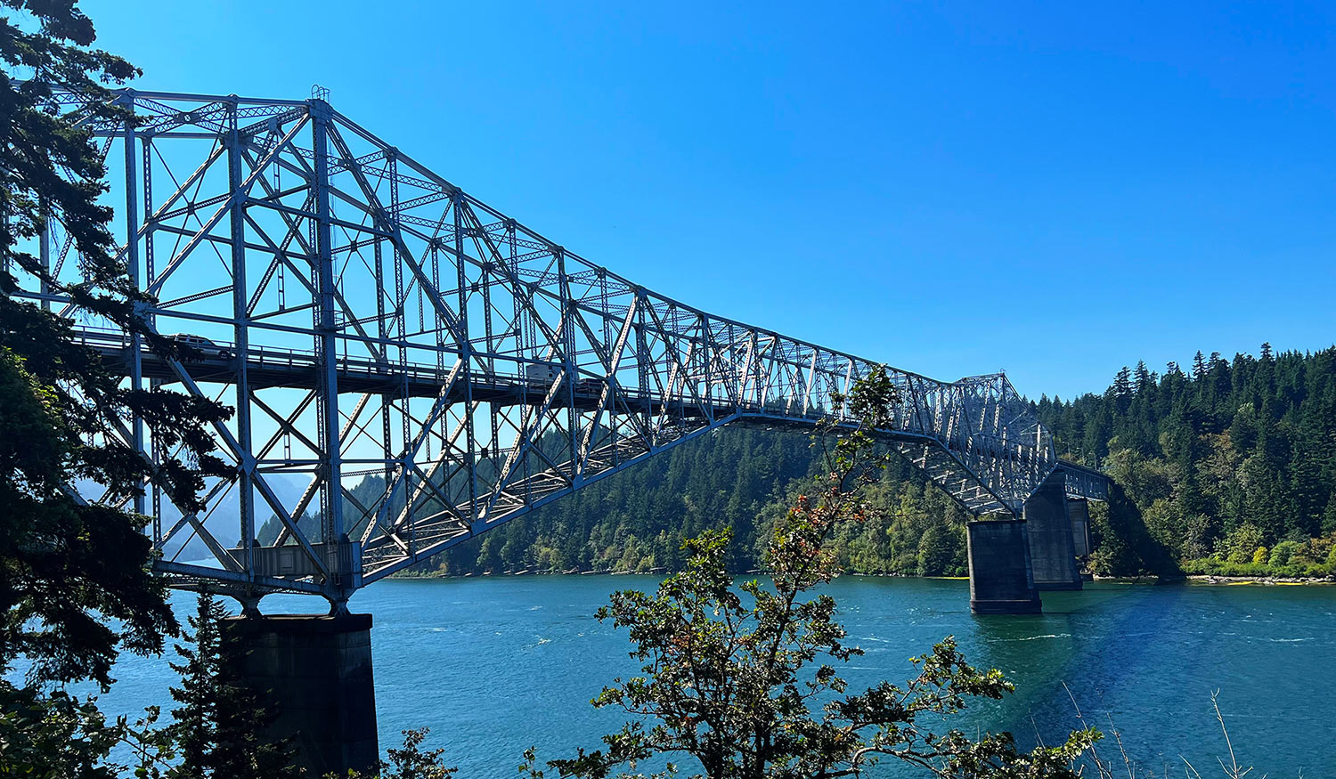
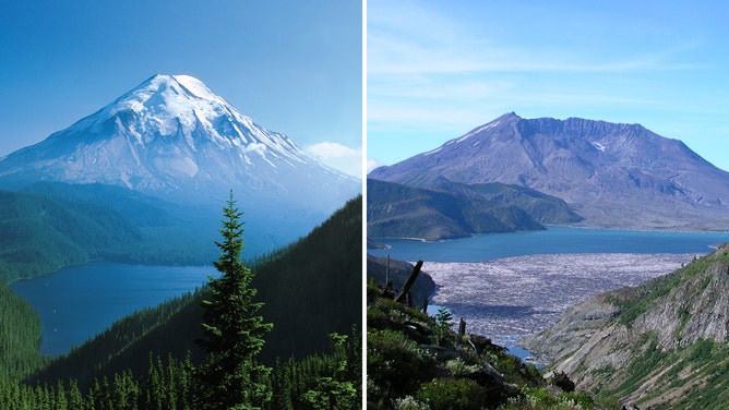